Nepal
Eastern Region

Discover travel destinations of travelers writing a travel journal on FindPenguins.
Top 10 Travel Destinations Eastern Region
Show all
Travelers at this place
    • Day 12

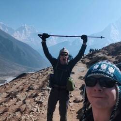
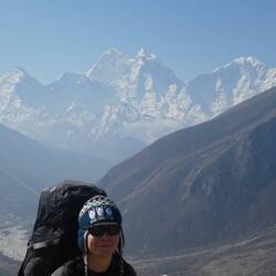
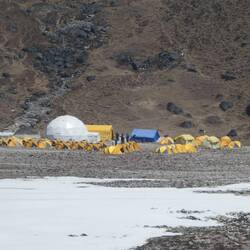
      Day 12: Goli Gumba to Pikey Pk Base Camp

      April 1 in Nepal ⋅ ☀️ 17 °C

      Three whole kilometres of flat ground? Surely an April Fools' joke, we thought, but no. A gentle start from Goli Gumba eased us into the day's walking until we reached a dusty ascent, where some locals who were trying to kick a motorbike into gear (at 3000 m of all places) took an interest in us, and resulted in a bit of a bizarre selfie. What followed was a moderate climb through mossy, enchanting woods, which seemed to be dripping in colour: of red rhododendrons, blue blooms of flowers, rich in green shrubs, and bountiful in butterflies, especially given the altitude.

      The journey was honestly a peaceful and enjoyable one, and it felt like no time at all until we'd pulled into a little teahouse for some chow mein lunch at 3400 m, with the growing Himalayan range staring back at us. The Nepalese who we came across at that teahouse were exceptionally hardy people, and we saw the old lady who we figured must've been in her eighties and a lama at the adjoining monastery, hauling a giant basket of firewood up the steps all while balancing the load with nothing more than her head (!) I don't know about your nan, but my nan struggles to walk in a straight line while carrying a cup of tea in her living room even (bless her), god knows how she'd fare with a ton of bricks on Kilimanjaro (sorry nan.)

      Our final stretch of ascent was drawn out over the next few hours as we battled a shortness of breath due to the dwindling atmospheric oxygen, while passing little patches of ice on our way up to Pikey Peak base camp at an altitude of 3730 m. Here, we were surprised to see one thing, other trekkers?! Where the hell have they come from, and why are there suddenly so many? Realising that we won't be enjoying much solitude beyond this stage, I think we both have renewed cheer for how we'd chosen to do the previous sections, having enjoyed whole teahouses to ourselves literally every day. Still, with the chance to talk to some fluent English speakers, we met a South African couple who'd been travelling for over 2 years straight, survived death from a Laotian bus crash, and where the husband had been an understudy to Archbishop Desmond Tutu back when he worked. Pretty cool. And with that, we set down the shutters and prepared for a 4:30 am awakening to ambush Pikey Peak at dawn.

      P.S. First day without signal so you won't see this as I write it!
      Read more

    • Day 14

      Day 14: Junbesi to Ringmu

      April 3 in Nepal ⋅ ⛅ 16 °C

      Leaving our packs behind in Junbesi, we decided to take a short break out of our trek and instead took a morning stroll up to Thubten Choling, the largest Buddhist monastery in Nepal. A huge untroubled community of nuns and monks living harmoniously in a 3000 m village embellished with intricate colourful ornaments. I have to say, it's the first time I've ever visited any place of religious significance and realised that this could easily be a salvation for its members. We saw the prayer wheels inscribed with mantras rotating due to the cleverly engineered flow of water, while robe-wearing monks roamed between vibrant buildings amid tranquil chiming and all the children seemed to be learning to make pottery at school. After wandering questionably into a very holy looking building, we found a place to buy some prayer flags, beautifully hand painted postcards, and a notebook handmade with an ancient paper making technique. It was such a peaceful place, and honestly, I'm not religious myself, but if I was, Buddhism would be the one for me. (And we did also buy toilet paper there, so maybe that'll make my holes holy after all?)

      Returning to our lodge in Junbesi, we each devoured another of our favourite pizzas yet and some cadbury's we'd wangled at a shop, before making haste in the heat onward on the trail. A stuffy ascent sent us up to Phurtheng, where I decided to stop to enjoy the view over a cup of tea. Here, the host of the teahouse was a very sweet guy, a Sherpa who had lived there his whole life, and entertained our stop by explaining the extent of the traditional route and how the sections from Jiri had suffered hugely in business since most people now choose to fly into Lukla. One thing about him, just as is common with many Nepalis, was just how humble he was, placing his hands together almost in prayer and grinning with a huge smile in response to every 'namaste'. Ending the day with a further down then up through a valley via a hanging bridge, we have called it a day in Ringmu, where a busier teahouse continues to wane our wearies.
      Read more

    • Day 16

      Day 16: Jubing to Puiya

      April 5 in Nepal ⋅ ☁️ 8 °C

      If yesterday was the downhill day, then today was definitely the uphill one, with 1,500+ m of steep ascents up through Kharikhola, Bupsa and Kari La.

      Before all that scrambling though, just leaving for the morning as usual became something of a struggle. And not for any of the normal reasons: as we'd left our window open while packing up our things, a monstrous winged beast kamikazed its way into our room like some buzzing Chinook locking onto its target. We both took one look at this thing and noped our way out of that situation, fleeing our room without hesitation, deserting our belongings and hiding behind the door from the wrong side. This insect, which we later discovered to be called a mammoth wasp (literal species name), was MASSIVE, with a chunky black torso and a buzz like an industrial lawn mower. Once we'd waited out the 'death hornet' as we'd called it, to leave back out through the window from which it came, we were able to make our way, but quickly came across another oddity in nature, witnessing streams of caterpillars following one another everywhere and all over the forest, apparently going off on little adventures to pupate into butterflies together.

      On the more human side of the climb however, our progress was slow in the heat, and we worked our way laboriously up to Bupsa for some lunch. Here, Thomas was particularly feeling some struggles on the ascent, but we took the time to unwind over some mango juice and spaghetti while a small Nepalese toddler took an eager interest in us. The way up from Bupsa to Kari La proved much friendlier despite the elevation gain, especially with the wider, more gentle paths which are used for jeeps up until Thamdanda. Between Kari La and Puiya, we witnessed whole herds of horses (or maybe mules given their donkey likenesses?) hauling supplies and gas bottles up the mountainside, and then the end of the road (/dirt track) where colossal landslides had taken place, trapping some vehicles and straight up destroying others. This evening, we've styled out our exhaustion by going head to head playing cards, where of course I won, (but Thomas might tell you differently.)
      Read more

    • Day 23

      Day 23: Dingboche to Lobuche

      April 12 in Nepal ⋅ ☀️ -4 °C

      We tried to navigate our own way around a lump of earth straight out of Dingboche to avoid climbing it (for no reason other than we're lazy to be honest) and in doing so, accidentally took an unnecessarily indirect route to the start of the path towards Lobuche.

      The route which followed was a dusty and gentle incline, but with the altitude it soon became apparent that Thomas was struggling with lethargy and lack of being able to take a satisfying breath. And it's true, everything and anything can tire you out up here and it does make you feel extremely slow. But after he managed to collect some air, we shuffled on towards Thok La pass, negotiating a half-frozen stream set in the moraine on our way. Thok La was the most tiring portion of the day, another upward endurance test where stopping every few steps became basically mandatory. But once we finally reached the top, there were mass monuments to all those who had died on Everest down the years, while the outrageous view from every direction was joined by a new glaciated feature: Pumori peak. With the ground levelling out, we entered the final valley which leads up to Everest Base Camp, and new peaks unfolded as appropriate. Rolling into Lobuche, it's been business as usual in unwinding and recollecting our sanity at a teahouse, this time at an altitude of 4,920 m. If all goes to plan, and we weather the -30°C night (possibly exaggerating but not sure), tomorrow we hit Everest Base Camp.
      Read more

    • Day 24

      Day 24: Everest Base Camp

      April 13 in Nepal ⋅ ☀️ -12 °C

      Time for a much overdue footprint if phone signal permits. Our experience of Lobuche was relatively pleasant and the night nowhere near as cold as we'd expected.

      Our first mission getting going for the day: get to Gorak Shep. Gorak Shep is the highest settlement anywhere before Everest Base Camp at an altitude of 5150 m, where atmospheric oxygen levels are 50% what they are at sea level, so as you can imagine, everything feels a lot more lethargic up there.

      This section was split into two parts: the first, a gentle amble up the valley; the second, a tiring scramble up, down, forward, and back over the glacier's scattered scree. After a few draining hours, we reached Gorak Shep and whacked down our big bags into our room, before slumping into the dining room for some lunch. At this point, Thomas confessed his questionable condition (altitude sickness is a bit like that, you can feel decidedly unwell but sort of confused as to how?), while I was also showing some signs of being worse for wear (namely, extreme tiredness and an aggravated cough famously dubbed as the Khumbu cough.) Anyhow, we mustered our strength and decided to push onto Base Camp while we still had the chance.

      By this point in the day, the regular afternoon clouds had begun to roll in, and the mild-sounding 2 miles onto Base Camp was beginning to drag, as we again navigated haphazard boulder fields which mounted the glacier. Turning a corner, you get your first glimpse of Base Camp itself, practically a vast city of yellow and orange tents which sprawl precariously all the way up to the Khumbu icefall. With our destination in line of sight, we descended a ridge and just like that, we'd made it!

      We afforded some subdued celebrations, hugging each other and enjoying the 5,364 m altitude as our trek's main objective. We then joined the queue (yes, queue) to get a picture with the famous 'Everest Base Camp' boulder and newly installed Hillary and Norgay sign where we commemorated our place under the world's tallest mountain with some quietly pleased pics.

      As we still mooched around at Base Camp, the heavy clouds began to spew spatterings of snow down: the start of the 5 cm of snowfall forecast for the afternoon! Fearing a blizzard, we lumbered our way back to Gorak Shep, admiring the surroundings as they turned from snow-dusted to snow-buried. Still, we got back in one piece (or two pieces), tucked away some food, and hunkered down for the coldest night yet: Gorak Shep is so high and so cold that they don't even have water.
      Read more

    • Day 25

      Day 25: Kala Patthar

      April 14 in Nepal ⋅ ☀️ -12 °C

      Everest Base Camp may be what everyone sets out to do, but in my opinion, Kala Patthar is the real jewel in the trekking crown. Kala Patthar is a 5,645 m vantage point with gorgeous vistas over mahoosive peaks in every direction. It sits some 300 metres above Base Camp and comes with an even more stark view of Everest unlike any we'd seen before. So with the hour barely 6 am as we departed Gorak Shep, we were delighted to bear witness to the perfect conditions: shimmering snow, unblemished blue skies, and the sun's rays gently easing in the day from over the Himalayan horizon. It was peaceful bliss. Or at least it would've been if not for the punishing ascending altitude we were about to undertake.

      As we began our ascent, we were surprised to see other trekkers descending already, at 6 am? That's keen, we thought, as we continued to shuffle our way up the icy incline. Thomas seemed to be coping okay but I've got to say, it was the hardest 'easy' climb I've ever done; wheezing for breath after every few steps and ascending in painful slow motion. I say 'easy' climb because, if not for the altitude, it really should've been. But my god, altitudes that high can be crippling not only on the legs, but on the lungs, and even the brain too, taking sheer determination to stagger to the summit. It had taken us three hours to complete the 500 m of ascent, and our prize: front row seats in an amphitheatre of dramatic snow-capped mountains, headed by its showpiece: Mt Everest, the tallest on Earth. Perhaps ironically though, Everest was probably one of the less impressive views, with Pumori, Lingtren and the nearer Nuptse jarring into the sky, all appearing larger. Still, we lingered on the view out in every direction, and gawped at the climbers' route up to Everest's summit via the wild Khumbu icefall and lumpy Hillary step. Here, we also enjoyed some more enthusiastic celebrations and snapped plenty of photos in the still solitude of the summit. I also got to wave my Kala Patthar hat from the very place it described.

      The descent back down was much more brisk, and upon returning to the teahouse, we decided on the first food of the day. I knew something wasn't quite right: I'd felt hungry, but also that I didn't want to eat. Still, I picked away at a pancake and we eventually set off on our way back down. We'd made it barely a few steps out from the front of the teahouse when I then paused to put on my sunglasses, turned, and threw up both violently and repeatedly. Shit. Vomiting isn't a particularly good sign when it comes to altitude, and combined with the symptoms both Thomas and I had been experiencing over the previous couple of days, we decided we needed to take more responsible action and adapt our plans. We had previously intended on attempting the giant Cho La pass over a glacier to Gokyo lake, thus hoping to end today in the village of Dzongla. But feeling rough in ourselves, we instead descended back to Lobuche, where we'd evaluate our plans going forward.
      Read more

    • Day 25

      Zurück vom Everest

      October 8, 2019 in Nepal ⋅ ☀️ -1 °C

      Hallo meine Lieben,
      schön wieder bei Euch im virtuellen Leben zu sein.
      Die letzten Tage hatten es in sich. Mir war bereits seit der Anreise ständig kalt. Eine Erkältung kam pünktlich zum Anstieg auf die 5000m Grenze. Das Gerotze hielt praktischerweise die Zigaretten auf Distanz.
      In der Höhe verlangsamen sich auch die einfachsten Denkprozesse - halbe Stunde Rucksack packen, 15 Minuten Denkarbeit für eine Bestellung “Spaghetti mit Käse“. Sonst faire Bedingungen. Kein Kopfschmerz, wenig Schnappatmung, erhöhter Herzschlag bei Anstrengung, immer Kraft im Körper.
      Wir hatten sehr viel Glück mit den Wetterbedingungen. Seit Namche Bazar kein Regen am Morgen oder am Tag. Der Himmel riss auf am sechsten Tag in Dingboche. In der entscheidenden Phase jeden Morgen klar. Später zogen aus den Tiefen langsam die Wolken hoch.
      Highlights: Kalla Patthar, Gletscher Base Camp, Lotse, Pumori, Ama Dablam.
      Soweit sehr zufrieden. Den Plan einen weiteren Pass von 5400m zu überqueren wurde von mir gecancelt und der Abstieg eingeleitet. Mir geht's auch schon wieder besser. Der Rückflug ist auf den 10. angesetzt, bleibt aber eine Trickkiste. Zur Zeit kommen und gehen aufgrund der Wolken in Lukla kaum Flugzeuge an.
      Auf bald ...
      Read more

    • Day 12

      Himalaya Tour Summary

      April 19, 2022 in Nepal ⋅ ⛅ -2 °C

      Leider hat mich an dem Tag nach den Einträgen die Höhenkrankheit gut erwischt. Ab da habe ich mich erst einmal mehrere Tage appetitlos und mit möglichst viel Schlaf und Ruhe auf unserer Route weitergeschleppt.

      Als mein Körper dann kurz vor dem Everest Base Camp endlich aufgeholt hat, war ich froh, dass alles noch wie geplant geklappt hat und ich einen Teil der Reise noch mehr genießen konnte. Offensichtlich habe ich deshalb gemischte Gefühle über die Reise, aber der Teil des Himalayas, den wir gesehen haben, ist insgesamt schön und beeindruckend und ich würde es weiterempfehlen, wenn man tendenziell wenig Probleme mit der Höhenkrankheit hat oder ausreichend Zeit für die jeweilige Route mitbringt. Zum Everest Base Camp fand ich unsere Route einen schönen Kompromiss aus Dauer, Natur und anderen Touristen (Base Camp über Gokyo Valley).
      Read more

    • Day 272

      EBC Trek 6: Hike high - sleep low

      November 5, 2022 in Nepal ⋅ ☀️ -5 °C

      Die Nacht war leider ein weiteres Mal bescheiden 😖.
      Ich konnte wieder ewig nicht einschlafen, erst war es zu kalt, mit Schlafsack dann irgendwann zu warm und wir beide wurden mehrmals in der Nacht mit dem Gefühl, nicht genug Luft zu bekommen, wach, bis am Morgen dann Manu eisig kalt war.

      Also stehen wir auf und genießen erst einmal ein kleines Frühstück mit Kaffee und Kakao, während wir übereinstimmend feststellen, dass heute der erste Tag ist, an dem wir so überhaupt keine Lust auf eine Wanderung haben. Wir sind müde, mein Kopf und meine Schultern schmerzen und das Atmen fällt uns immer noch schwer.
      Aber, es gibt keine Ausreden, gerade auf der jetzigen Höhe ist die Akklimatisierungswanderung wichtig, insbesondere wenn man schon leichte Kopfschmerzen etc. hat.

      Für die meisten Menschen ist eine Höhe von 3.000 - 6.000 Meter über dem Meeresspiegel nicht das, woran der Körper täglich gewöhnt ist. Bei 3.000 Meter zum Beispiel liegt der Sauerstoffgehalt bereits bei nur noch 70 % des normalen Wertes, bei einer Höhe von 4.410 m wie in Dingboche bei nur noch 60 %. Bei Wanderungen in diesen Höhen muss der Körper viel Energie aufwenden und sich darauf einstellen, weniger Sauerstoff zur Verfügung zu haben. Ein zu schnelles Aufsteigen kann daher zur Höhenkrankheit (Schwindel, Kopfschmerzen, Übelkeit) und möglicherweise noch gefährlicheren Komplikationen wie einem Gehirn- und Lungenödem führen. Um dem vorzubeugen, ist es also nötig ein paar Spielregeln einzuhalten. Man sollte die jeweils aktuelle Höhe um nicht mehr als 300-500 Meter pro Tag erhöhen und jeweils mindestens einen Pausentag einlegen, wenn man insgesamt 900 - 1000 m Höhenmeter überwunden hat.
      Die an solchen Tagen empfohlene Wanderung in eine höhere Höhe mit anschließendem Abstieg bereitet den Körper auf die in den folgenden Tagen noch zu erreichende Höhenmeter vor, ohne in die Gefahr der Höhenkrankheit zu kommen.

      Da wir das ja nun alles schon wissen, ziehen wir uns nach dem Frühstück um und machen uns widerwillig gegen 10 Uhr auf den Weg in Richtung Nangkartshang Peak, einem Gipfel auf 5.083 m 🙈😳. Für diesen Weg packen wir dann auch heute das erste Mal die zweite Lage Wanderkleidung, inklusive Handschuhe und Mütze aus.

      Der Weg führt uns aus Dingboche direkt auf den umliegenden Bergkamm und es geht 3 km stetig bergauf. Diese Wanderung ist mit Abstand die anstrengendste bislang und das sogar ohne Gepäck. Zunächst müssen wir ca. alle 10 Minuten eine Verschnaufpause einlegen, mit steigender Höhe erfolgt diese nach fast allen 20 Schritten 😮‍💨😮‍💨. Würden wir auf den letzten Metern nicht den Gipfel schon sehen, wir würden überlegen umzukehren. Aber so bezwingen wir den letzten Aufstieg nur noch durch reine Willenskraft und sind auf unserem ersten 5.000er angekommen 🥳🥳🥳. Von hier aus sehen wir nun auch die ersten Gletscherseen Chola Lake und Dowo Tso. Eine traumhaft schöne Aussicht. Ein paar schnelle Bilder und eine glückliche Umarmung später machen wir uns dann aber auch schon wieder auf den Rückweg und stolpern die steilen Zickzackwege wieder hinunter. Der Wind bläst uns eisig um die Ohren und wir sind überglücklich, als wir in unserem, von der Sonne aufgewärmten Zimmer ankommen. Die Wärme im Zimmer führt dann auch dazu, dass wir ein wenig Schlaf nachholen können und am späten Nachmittag mit einem riesigen Hunger aufwachen.

      Langsam trudeln auch die Wanderer aus Tengboche ein und wir sitzen den Abend im warmen Gemeinschaftsraum mit Nudeln und Tee und können noch den golden leuchtenden Gipfel des Ama Dablam bestaunen.
      Zwei Nächte und zwei Wandertage trennen uns nun noch vom Everest Base Camp ✊🏻✊🏻.

      Heutige Wanderung von
      Dingboche 4.410 m
      zum Gipfel Nangkartshang 5.083 m
      und zurück nach Dingboche 4.410 m

      Strecke insgesamt: 6 km
      Höhenmeter aufwärts: 708 m
      Höhenmeter abwärts: 709 m
      Reine Laufzeit: 3:11 h
      Read more

    • Day 273

      EBC Trek 7: Von Dingboche nach Lobuche

      November 6, 2022 in Nepal ⋅ ☀️ -7 °C

      Die heutige Nacht war fast schon richtig gut, die Temperatur hat gestimmt, das Atmen viel uns leichter und sogar geträumt habe ich irgendwas, was zumindest heißt, dass ich mal richtig am Schlafen war 😅👍🏽.

      Wir lassen am Morgen die aufgehende Sonne noch unsere Klamotten aufwärmen und das Handy aufladen, bevor wir gegen 10 Uhr wieder auf dem Trek sind.
      Heute stehen noch mal um die 8 km und „nur“ 500 Höhenmeter auf dem Programm, sodass sich die ersten 4 km relativ entspannt auf einer Hochebene mit nur leichter Steigung gehen lassen. Die gestrige Höllenwanderung hat uns in jedem Fall ganz gut getan und wir fühlen uns auch recht fit. Nur richtig eisig ist es jetzt geworden, -4 Grad zeigt das Thermometer, aber die Sonne scheint weiterhin den ganzen Tag für uns und lässt uns den kalten Wind besser ertragen 🤩.

      In dem kleinen Ort Thukla machen wir eine kleine Mittagspause und sehen dabei bereits den uns bevorstehenden Anstieg 🫣🥵. Noch 3 km sollen es bis zu unserem heutigen Ziel sein, einer davon geht direkt in Serpentinen und Felsstufen steil bergauf und verlangt uns nochmal alles ab. Mit vielen kleinen Pausen kommen wir aber nach einer knappen Stunde oben an und sehen erstmal unzählige Steinstapel in der Fläche. Es handelt sich hierbei um einen Gedenkstätte für alle Todesopfer der Besteigungen des Mount Everest (und auch der anderen umliegenden Gipfel). Jedem Toten ist mit einem sogenannten Steinmann, die letzte Ehre erwiesen, manche Verstorbenen haben einen Art Schrein mit Inschriften. In jedem Fall sind hier ziemlich viele dieser Steinmännchen, die Inschriften zeigen, dass die meisten erst beim Abstieg verstorben sind. Ganz schön heftig zu sehen aber auch noch einmal mahnend für alle.

      Die letzten zwei Kilometer gehen zum Glück wieder relativ flach auf einer weiteren Hochebene entlang, denn selbst hier merken wir immer mehr die müden Beine, den schmerzenden Rücken und vor allem die dünne Luft. Und dann sind wir in Lobuche auf 4.910 m angekommen und beziehen das nächste kalte Zimmer und versuchen in den letzten Sonnenstrahlen noch ein wenig die nass geschwitzten Klamotten zu trocknen.

      Am Abend wird der Ofen angemacht und wir wärmen uns noch ein paar Stunden in dem Gemeinschaftsraum auf, bevor wir uns mit Schlafsack und Decke ins Bett einmummeln und darauf warten, dass es warm wird.

      Heutige Wanderung von
      Dingboche 4.410 m
      bis nach
      Lobuche 4.910 m

      Strecke insgesamt: 8,8 km
      Höhenmeter aufwärts: 830 m
      Höhenmeter abwärts: 203 m
      Reine Laufzeit: 3:17 h
      Read more

    You might also know this place by the following names:

    Purwanchal, Eastern Region, 동부 개발 지구, पूर्वाञ्चल विकास क्षेत्र

    Join us:

    FindPenguins for iOSFindPenguins for Android