- Tunjukkan perjalanan
- Tambah ke senarai baldiKeluarkan dari senarai baldi
- Kongsi
- Hari 1
- Khamis, 21 Mac 2024 7:15 PTG
- ⛅ 12 °C
- Altitud: 142 m
EnglandLuton Airport51°52’49” N 0°22’31” W
Day 1: STANDBY

Lego, Luton & Losing Our Minds
"I can't see a single thing going wrong this whole trip." I believe those were the words I'd uttered to Thomas upon entering through the main entrance doors to London Luton's departure terminal, in a confused tone, feigning confidence and bemusing sarcasm. It took a matter of mere minutes, and lo and behold, something went wrong (very wrong and very quickly). Standby?! Within an instant we'd gone from marvelling at our backpacks weighing only 11.1 kg and 11.2 kg respectively, to being told that we plainly had very little chance of getting on this flight at all.
So here's how it figures: Wizz Air overbooked our flight to Cluj-Napoca. I know, how does that even happen? And not by one person or even two people, but by TEN people! So what about our onward flights?? What about Nepal? As much as we tried to reason for a human explanation from the woman at the check-in desk, she was quite insistent that they can 'legally do that as per the Terms & Conditions' (thanks, very helpful) and between joking with her colleague, at least found the time to explain that we'd only know if we could board our flight at the gate itself. Well, shit. So with little more to go on, Thomas made a quick call to Chris to explain the situation, who scoured our insurance details and somehow managed to magic up a whole new backup route within the hour, to Abu Dhabi via Paris just in case. Amid the melee of the confusion, Thomas decided it'd be the perfect time to have a browse around the Lego store in duty-free (interesting choice of timing, I know.) Anyhow, between frantic attempts to book seats for our onward flight to Abu Dhabi to avoid this happening again, and despite the lack of phone signal (as well as the fact that it wouldn't even matter if we couldn't get to Cluj anyway), we beelined our way to Gate 27 to salvage what hope we had left of boarding this flight to Romania. It wasn't looking hopeful, the queue seemed to snake so far that it may as well have just zigzagged to Romania itself, and after having been sidelined by the big STANDBY letters scrawled all over our boarding passes, we watched on as almost every other passenger passed through. Finally, and only when everyone else had boarded, it became apparent that we might just make this flight after all...?! With 6 seats empty, we were very luckily chosen to sneak through and onto the plane, with me even taking the seat of one dude who rocked up to the gate literally seconds after it closed! (Sorry, not sorry). Touch and go, but we're on our way to Cluj... Now just to see if our bags end up there too ! 🥴
Big big big thanks to Dad and Mum for driving us up to the airport, and not least Chris for being on call for some admin shenanigans. This leg to Abu Dhabi had already been a rollercoaster, even before today. Our prior flight booked via Izmir, Turkey with Sun Express, a Lufthansa-Turkish mutant airline was trivially cancelled almost 2 months ago. Who says lightning doesn't strike twice?!Baca lagi
- Tunjukkan perjalanan
- Tambah ke senarai baldiKeluarkan dari senarai baldi
- Kongsi
- Hari 2
- Jumaat, 22 Mac 2024 7:36 PTG
- ⛅ 9 °C
- Altitud: 325 m
RomaniaCluj-Napoca International Airport46°46’56” N 23°41’19” E
Day 2: Cluj-Napoca to Abu Dhabi

After touching down in Cluj-Napoca at 01:15 am and with nowhere in particular planned to stay, we were in no particular rush to leave the warmth of the airport for the bitter Romanian night. It also wasn't long before being reminded of what an absolute silly goose of a man I am, as I soon discovered I'd *already* lost my hat, less than a day into the trip. (Don't ask, I'm not over it yet). So after staying up all night, revising an academic paper on seal populations (Thomas) and reading about Joan of Arc (JJ), we took the opportunity at first light to get a glimpse of the real Romania, hopping onto a packed bus in the freezing conditions. My first impression of Cluj was of this: Eastern, concrete, brutalist, high-rise Soviet style apartment blocks which lined the wide boulevards jammed with loud Dacias. But as we strolled into the centre, the run down bits made way for the beautiful ornate architecture and grand religious buildings of the old town. Following a gander of the city's main sites, we then spent the mighty sum of 21 LEU (£3.62) between the two of us to buy enough food to get us through to Nepal, before hopping on a bus back to the airport, where I apparently asked the driver "are you going to Cluj?", the very place we were in (his confused look reflecting the lack of sleep getting to me I think). Upon our return to departures, we saw the magnificent workings of a Romanian airport, such as a local worker using power tools which spewed glowing embers down onto members of the public from above (very safe), the questionable mire of tangled power lines on practically every utility pole, and boarding gates made out of essentially makeshift shipping containers, before boarding our flight to Abu Dhabi (this time no issues). 5hr of intermittent sleep and views over Iraq later, and we're here, in my first ever experience of a Premier Inn (so this trip is clearly worth it now). 😎Baca lagi
- Tunjukkan perjalanan
- Tambah ke senarai baldiKeluarkan dari senarai baldi
- Kongsi
- Hari 3
- Sabtu, 23 Mac 2024 7:48 PTG
- ☁️ 29 °C
- Altitud: 11 m
Emiriah Arab BersatuQarn Nuşaylah24°27’5” N 54°38’32” E
Day 3: Abu Dhabi to Kathmandu

Halfway through writing yesterday's post, Thomas turned to me and said "Are you enjoying being incontinent number two?" As much as it made me chuckle at the time, I'm fairly sure he was referring to our touchdown in UAE being our first venture into the second continent of our trip, and first steps (ever!) into Asia, and not in fact a reference to a lack of voluntary control when it comes to needing the toilet. In some twisted tempt of fate though, I think the universe was laughing at us, because it wasn't long before Thomas became incontinent number one for real, coming down with something of a swirling illness. Still though, we did have another flight to catch, and after barely 6 hours of sleep in the Premier Inn (where we didn't even get time to sample the pool!), we were off again, shuttle bussing our way back to the airport amongst perhaps the only rain deserty Abu Dhabi might experience all year. Thankfully, its airport was decked out with plenty of facilities for Thomas, and we were officially making headway for Kathmandu after the bizarre repeated chanting of 'Allahu Akbar' over the tannoy on our Air Arabia flight take off.
In our eagerness, we might've mistaken nearly every cloud for some glaciated Himalayan peak, but when we finally descended through the haze, we laid eyes upon Kathmandu for the first time, sprawling out in every direction as far as the eye could see. The next task was something of a confusing one as we navigated the visa application process, our own Britishness probably working against us as we incorrectly joined pretty much every queue in immigration. In fact, by the time we'd figured it all out, there was no one left manning passport control to even let us in. Eventually though, we made our way through and bought SIM cards and a taxi ride into town from some friendly faces, so friendly in fact that we thought they might have been scamming us, but they can't have done because we each spent only £4.16 on 20 GB SIM cards, and £2.68 on the taxi. A personal highlight was one guy trying to give me his business card as a local mountain guide, only for, when I tried to take it, he said I couldn't because it was his only copy lol.
Still, the taxi ride through the city was an overload of the senses: cars honking and swerving recklessly, monkeys running between people, narrow twisting streets crammed with interesting trinkets. Before long, we'd arrived at Hotel Premium, and boy, is it premium here (and it better be for £3.68 each a night.) Taking some short time to relax, we suddenly remembered that eating was a thing you're sort of supposed to do, and headed up to the rooftop restaurant for a hearty vegetable curry. It's not based on a lot, but I think we both love Nepal so far! And with that sentiment we returned to our room, where I finally put pen to paper on the contract for my job starting in September and we drifted off into a deep slumber.Baca lagi
- Tunjukkan perjalanan
- Tambah ke senarai baldiKeluarkan dari senarai baldi
- Kongsi
- Hari 4
- Ahad, 24 Mac 2024 1:38 PTG
- ☁️ 22 °C
- Altitud: 1,309 m
NepalThamel27°42’56” N 85°18’32” E
Day 4: Holi Festival

Holi is the sacred ancient Hindu Festival of Colours, Love and Spring, marking the end of winter and victory of good over evil. And so, after a morning pitstop for some fruity breakfast, we only had one thing on our minds: to get stuck in with the festivities.
The celebration itself involves hurling powdered paint at targets who mark their willingness by sporting white t-shirts. But first, to find some white t-shirts of our own. And we barely had to stumble over the front doorstep before finding one of the hundreds of sellers lined up along the street with t-shirts and paint. Delighted with our new purchases, we retreated back into the room and prepared for the dousing of our lives, stripping ourselves of anything valuable and bracing for an art-inspired whirlwind. Thomas even took his backup phone in a waterproof cover, while I chose not to take a phone at all. We'd heard that Durbar square, the bustling 4th-8th century-built centre where Nepal's kings had been crowned, was the liveliest place to see the hellfire of paint rain down, and so we headed off south, unknowing of what to expect from the day.
Shortly after setting off, we soon discovered exactly what to expect, as gangs of kids hiding out behind corners of buildings and camped up on balconies sniped us with water guns and flung paint at us like seasoned professionals. It has to be said, we gave as much as we got, even if we did just hand over 3 bags of coloured powder to some little kids out of misunderstanding. By the time we'd reached Durbar square, we were certainly looking colourful, and about to reach new levels of vibrance. The square itself was rocking, crammed with Nepalis drumming from the slopes of the temples, and flooded by carnival goers joining the procession. The joy and enthusiasm was infectious; locals would come up to you and gleefully smear powder all over your face, capped off by a 'Happy Holi!' on their escape. The friendliness of the natives also added to the warm feeling, with their eagerness to join our pictures while encouraging us to dance to the traditional music.
After several hours of engaging in colourful combat, we eventually became drained from the jolly-up and decided to make our way back, finding ourselves taking a different route back amid the maze of streets. As we ventured down one narrow street which comically didn't deter people despite being dug up by an excavator, which itself was perilously close to the low-hanging power lines, we met a boy named Badal. Badal seemed like a nice kid, and he asked if we wanted to see where he went to school. Now, I'll say this; we usually wouldn't have fallen for that, but having just experienced the kindness of the Nepalese people, we didn't see anything wrong with talking to this kid for a bit longer. Long story short, after drinking tea with us at a nearby café, he ends up leading us into what becomes apparent to be an art shop, where we were somewhat scammed into buying a painting, albeit only scamming us out of about £20. Foolish of us I know, and a shame of them to take advantage of the atmosphere to lure tourists in, but hey we shan't dwell, you live and you learn.
All in all, a very enjoyable and memorable day, made all the more memorable by the clean up that followed (two showers still isn't enough, my hair might be green forever)Baca lagi
- Tunjukkan perjalanan
- Tambah ke senarai baldiKeluarkan dari senarai baldi
- Kongsi
- Hari 5
- Isnin, 25 Mac 2024 1:37 PTG
- ☁️ 20 °C
- Altitud: 1,398 m
NepalSwayambhunāth27°42’54” N 85°17’25” E
Day 5: Kathmandu

After a much-sleepless night, still programmed for Greenwich Mean Time, we eventually hauled ourselves from our weary room and headed to our favourite eatery across the road, where we'd now become regulars. There, sat over the dish of the day, we discussed the plan of action of the day in order to prepare for our upcoming trek. Item one on the agenda: finding cash. Up until now, we'd somehow lasted with a threadbare supply of Rupees we'd ordered in prior to our trip, but now we very much needed a healthy supply to get us through our rural route to follow. Sorting this out after identifying the lowest fees by fiddling with a collection of ATMs, we turned our attention to visiting the British embassy, where we figured we'd drop them a 'tally ho' and doff a scone in their general direction to let them know we'd be doing our own independent trek in case anything goes wrong. The journey there was something of an experience in itself, honestly I could write paragraphs and paragraphs just about *crossing the road* alone. Yes, you too can cross a Nepalese road by following these simple and easy instructions:
1. Step out in front of the hoards of manic, speeding traffic.
2. Pray.
And so after experiencing my life flash before my eyes a mere handful of times, we reached the barbed-wire gates of the embassy, where frankly they couldn't give enough of a toss about our intentions to let us in (so we wrote them an email instead.) Bored with our chores already, we headed back in the other direction, stopping only at a fake outdoor gear shop in Thamel to find me a snazzy, new (and forged) arc'teryx hat, where we then marched onwards through the backstreets to Swoyambhu Mahachaitya (try saying that one three times in a row.)
Otherwise described as 'the monkey temple', this stupa is one of the most important and sacred pilgrimage sites in Tibetan Buddhism; an ancient complex of temples, shrines and monasteries rising high on a hill above western Kathmandu, with the wafting of incense and mischief of macaques meandering the site. Ascending the steps was like climbing the stairway to heaven, where at the top, there were swathes of colourful prayer flags draped between the trees and the view of the city stretched as far as the pollution induced haze would allow in every direction. We took some time to enjoy the surroundings and relative peace from the streets below, even joking that Kathmandu would be where someone from Mumbai might come for a 'relaxing getaway.'
With thunder rolling in, we decided to take our leave, evading the monkeys and opting for a much more direct route back to the hotel, where the remaining evening was spent finally eating some food that didn't involve rice, and buying up supplies as we brace for tomorrow's horror show of a bus ride towards Jiri.Baca lagi
- Tunjukkan perjalanan
- Tambah ke senarai baldiKeluarkan dari senarai baldi
- Kongsi
- Hari 6
- Selasa, 26 Mac 2024 1:53 PTG
- ⛅ 15 °C
- Altitud: 1,922 m
NepalḌhuṅge Kholā27°38’11” N 86°13’43” E
Day 6: Kathmandu to Jiri

There are several trailheads to commence the trek into Everest Base Camp. Many tourists on a timescale choose to fly from Kathmandu straight into Lukla, with a reputation as perhaps the most dangerous flight in the world, where the short runway is bookended either side by a sheer drop and a huge cliff. On the other hand, some travellers prefer to rent a jeep and enter via Phaplu, while the more time-rich trekkers can choose to walk the extra 90 km+ by riding a bus into the small town of Jiri, taking some extra time to soak in rural Nepalese life and acclimatise to the ascending altitudes. Having weighed up our options and deciding we'd be best suited to take our time, we opted for the latter route, and having done our homework, set off to Jadibuti via taxi at 7 am, where we crossed our fingers in hope of finding a ride towards Jiri.
After rattling through the early streets of Kathmandu, our taxi driver pulled up on a busy road, wound down his front window and emphasised the word 'Jiri' to some locals who were causing the regular disruption. Within a matter of seconds, our haggling with the taxi driver had become well, obsolete, as we didn't even have time to break change before he'd opened his tailgate and allowed the locals to scurry off with my backpack. Alarmed at having had practically the entirety of my possessions walked off with, I rushed after the guy who took us to a bus where the driver claimed to be going to Jiri. Fair enough, we thought, there's no other way we'd know where the hell it's going, so we hopped on. At least by consolation, we weren't the only westerners on board; an American dude named Brock rocked up soon after, and it wasn't long before the bus was crawling along through the suburbs, recruiting locals on board seemingly at random. Passengers weren't the only thing this bus traded though, as we stopped at nearly every market en route for some new commodity, even picking up boxes and boxes of newly hatched chicks, which were crammed up into the overhead bag storage for the journey! Despite the persistent chirping which eventually became drowned out by the blaring traditional music, the journey was actually... alright?! We'd been braced for the ride from hell; we even read one article yesterday from someone who'd said something to the effect of 'it wasn't that bad' followed by 'only half of the passengers became travel sick' and 'we had to sit on top of the bus and dodge the power lines in the rain'. But in the end, despite an 8+ hour journey of incessant hairpin turns and crumbling cliffside roads, we didn't experience any of that and, dare I say, we actually kind of enjoyed the ride? Oh, and we did get smuggled off of our original bus and shoehorned into another that turned out to *actually* be going to Jiri at one point, but not much drama otherwise.
Anyhow, once we'd arrived in the Jiri rain, a local man greeted us straight off the bus and into his lodging, Hotel Everest, where we've spent the evening playing card games with Minnesotan Brock and local man Probin, and feasting on Tibetan Bread, dumpling-style MoMos and Dal Bhat.Baca lagi
- Tunjukkan perjalanan
- Tambah ke senarai baldiKeluarkan dari senarai baldi
- Kongsi
- Hari 7
- Rabu, 27 Mac 2024 2:56 PTG
- ☁️ 14 °C
- Altitud: 1,922 m
NepalḌhuṅge Kholā27°38’11” N 86°13’42” E
Day 7: Jiri

Okay, bit of a write-off day. After repeated bouts of throwing up and rejecting the contents of my stomach overnight (Dal Bhat I reckon) we decided to take the conservative approach and stay put for the day. Still, it's not been entirely unproductive, as I managed to join a call for UKAEA, and Thomas finished critiquing his paper to re-submit, as well as mingling with our hosts. We go again tomorrow 🫡Baca lagi
- Tunjukkan perjalanan
- Tambah ke senarai baldiKeluarkan dari senarai baldi
- Kongsi
- Hari 8
- Khamis, 28 Mac 2024 1:48 PTG
- ☁️ 14 °C
- Altitud: 1,773 m
NepalChāmlā Kholā27°36’32” N 86°17’43” E
Day 8: Jiri to Shivalaya

Today, we finally kicked off our trek, taking the first steps hopefully towards the slopes of the world's tallest mountain. Not a long day as of itself, but at least personally, a difficult one, and not on account of the mild 9.5 km distance, 600m ascent or altitude, but out of feeling so weak for illness and lack of having eaten for two days.
Still, we had plenty to appreciate, enjoying witnessing quiet rural life in the foothills of the Himalayas. As suspected, Thomas marvelled at the array of exotic birds, rhododendrons and every tidbit of biology he could feast his eyes upon, while the locals have been incredibly friendly, trading us a modest 'namaste' and pointing us in the right direction at every available opportunity. One thing we found particularly interesting was just how many tiny settlements are dotted all about: small farmsteads and tiny communities too insignificant to be classified as villages or even be granted their own names stretch almost continuously along the trail. It really does feel like if you slipped away to live a life as a humble Nepalese farmer, no-one might find you ever again. Perhaps also surprisingly, it's just SO quiet, with us seeing barely another western trekker the entire day, and so far we've been spoilt for choice for empty teahouses to choose between.
Shivalaya, our day one destination, is named after Shiva, the Hindu god of destruction amongst other things, and perhaps by fate of name was devastated by the 7.8 magnitude earthquake that occurred here in 2015. It's clearly been rebuilt since, and is a colourful but sleepy stopover, where we've bought our entrance through to the Gaurishankar Conservation Area for tomorrow's section and cooled off by actually eating something (me) and trying to ring his Nan twenty times (Thomas).Baca lagi
- Tunjukkan perjalanan
- Tambah ke senarai baldiKeluarkan dari senarai baldi
- Kongsi
- Hari 9
- Jumaat, 29 Mac 2024 2:33 PTG
- ☁️ 14 °C
- Altitud: 2,706 m
NepalDeurali27°34’57” N 86°19’51” E
Day 9: Shivalaya to Deurali

We were sad to say goodbye to cheerful Shivalaya, and even sadder to say goodbye to our teahouse host, Badar, who took the time to explain the religious and social changes Nepal has been going through over the past 20 years. Most interestingly, Badar explained how he himself was a Buddhist while his wife was a Hindu; something that would've been strictly forbidden under the caste system only two decades ago, as well as touching on other issues such as the impact of the internet on rural life, and the increasing shift to gender balance in Nepal.
After tipping freely in thanks for his hospitality, we were back on the trail again, and suddenly faced with an unrelenting 1 km ascent up to the village of Deurali, at an altitude of 2705 m. Here's the problem though, my illness had set in even worse today, with periodic sneezing, a sore throat, feverous chills, stomach cramps, and a complete decimation of energy levels to name but a few symptoms. But why has it been so hard to avoid illness so far? We don't know frankly, is it the food, the water, the foreign strains of sickly bacteria you simply can't avoid? Up until now, we've been double purifying our water supply, first using an ultraviolet steripen to disinfect it, followed by a treatment of Chlorine Dioxide solution to be extra sure of its cleanliness. Every time I'd been taking a gulp of our processed water though, it had only been adding to my thirst and further irritating my inflamed throat. I don't know if my body just doesn't agree with Chlorine Dioxide (Thomas has been fine after all), or if I inhaled one gulp of chlorine gas too many in its preparation, but I decided to switch over from chemical treatment to using my water filter with the steripen, which has been much better since.
Anyhow, the result of all this has been a painfully slow day without much significant progress. Still, Thomas (who enjoyed his healthiest day yet himself) punctuated the uphill heaves of footsteps by immersing himself in the Himalayan biology once again, even spotting a venomous Orange Collared Keelback snake under foot. Calling the day short at Deurali, it's been a quiet evening (again as the only guests here at all!) while I try to sniffle myself back to something resembling a healthy person.Baca lagi

PengembaraListen to your body & get yourself better. You've got plenty of time & need to adjust. Love you loads. Take care & enjoy
- Tunjukkan perjalanan
- Tambah ke senarai baldiKeluarkan dari senarai baldi
- Kongsi
- Hari 10
- Sabtu, 30 Mac 2024 2:34 PTG
- ☀️ 18 °C
- Altitud: 1,848 m
NepalTumbuk Kholā27°33’19” N 86°22’46” E
Day 10: Deurali to Namkheli

A shorter one today because I'm tired (but mostly feeling better minus a cold). After stepping out of the door from our teahouse in Deurali, we gazed out upon our very first view of snow capped peaks on the trek, with a clear view up to Pikey Peak and a handful of other mountains rising to 5,000m, which apparently given their abundance in Nepal, hadn't even been named. The descent from Deurali into Bhandar was a real highlight, passing through untouched local life, where the view into the vast valley was complemented by sightings of baby goats and namaste-nodding natives. Heading back up the other side from our low point of the day, the beating sun did its best to slow our ascent into Namkheli, during which some guy stopped to stare at us on passing, getting uncomfortably close to me while clutching a machete (no, really, we think he wanted cigarettes?) We've received some odd looks in Namkheli, I don't think they receive many western tourists here at all (if ever?), especially being slightly off the extended Everest Base Camp routes. Finally, with the sun setting, our day was capped off with our first experience of a full-on monsoon, blackening out the sparkling sky and scattered hillside lights with the violent crescendoing of thunder and eruption of a dense downpour.Baca lagi
- Tunjukkan perjalanan
- Tambah ke senarai baldiKeluarkan dari senarai baldi
- Kongsi
- Hari 11
- Ahad, 31 Mac 2024 2:30 PTG
- ☀️ 16 °C
- Altitud: 2,974 m
NepalNingali27°32’41” N 86°24’13” E
Day 11: Namkheli to Goli Gumba

Freshly fired up from our morning serving of Nepalese chapatti and honey, we set off for the beautifully clear day with a 1000+ m of ascent in mind before dark. In fact, with the altitude rising ~1200 m in a span of only 3.6 km, there was only one order for how today would go: uphill, uphill, then finally some more uphill.
But where to incline was where our confusion lay at first; steep, mazey tracks unmarked on our maps criss-crossed the mountainside making it tricky to find a consistent route. Hey, uphill is uphill, we thought, all roads lead to Rome, and kept hauling ourselves up blindly. Luckily, we did find our intended path, and managed to slowly crawl up in elevation, taking occasional shady breaks to discuss nonsense like every member of Bournemouth's championship winning side back in the day.
Visibility was stunning and once we'd ascended beyond 2450m, we could peer back down into the deep valley out of which we'd emerged, while, in the other direction, a magnificent cast of towering snow-capped characters emerged on the skyline. It was our first true view of the Himalayan massif (and wow they're beautifully big, and beautifully terrifying.)
Cue some more upward slog and Thomas using the camera's mind boggling zoom abilities to inspect the wildlife's tonsils, and we find ourselves at 3,000 m in Goli Gumba. And good golly (Gumba) indeed, there's no shortage of vantage points nor monasteries up here. Meanwhile, our teahouse for the night is again (and unsurprisingly at this point) completely empty, although the language barrier did result in us accidentally ordering double the amount of food to what we intended (oops). We then marvel at the sunset before I write these rambles* and call it quits until tomorrow.
*I'm also now preparing to run out into a storm to wangle some signal to upload this footprint, so you better be damn grateful to see this.Baca lagi
- Tunjukkan perjalanan
- Tambah ke senarai baldiKeluarkan dari senarai baldi
- Kongsi
- Hari 12
- Isnin, 1 April 2024 1:47 PTG
- ☀️ 17 °C
- Altitud: 3,731 m
NepalTori̇̄phule Ḍā̃ḍā27°31’37” N 86°27’52” E
Day 12: Goli Gumba to Pikey Pk Base Camp

Three whole kilometres of flat ground? Surely an April Fools' joke, we thought, but no. A gentle start from Goli Gumba eased us into the day's walking until we reached a dusty ascent, where some locals who were trying to kick a motorbike into gear (at 3000 m of all places) took an interest in us, and resulted in a bit of a bizarre selfie. What followed was a moderate climb through mossy, enchanting woods, which seemed to be dripping in colour: of red rhododendrons, blue blooms of flowers, rich in green shrubs, and bountiful in butterflies, especially given the altitude.
The journey was honestly a peaceful and enjoyable one, and it felt like no time at all until we'd pulled into a little teahouse for some chow mein lunch at 3400 m, with the growing Himalayan range staring back at us. The Nepalese who we came across at that teahouse were exceptionally hardy people, and we saw the old lady who we figured must've been in her eighties and a lama at the adjoining monastery, hauling a giant basket of firewood up the steps all while balancing the load with nothing more than her head (!) I don't know about your nan, but my nan struggles to walk in a straight line while carrying a cup of tea in her living room even (bless her), god knows how she'd fare with a ton of bricks on Kilimanjaro (sorry nan.)
Our final stretch of ascent was drawn out over the next few hours as we battled a shortness of breath due to the dwindling atmospheric oxygen, while passing little patches of ice on our way up to Pikey Peak base camp at an altitude of 3730 m. Here, we were surprised to see one thing, other trekkers?! Where the hell have they come from, and why are there suddenly so many? Realising that we won't be enjoying much solitude beyond this stage, I think we both have renewed cheer for how we'd chosen to do the previous sections, having enjoyed whole teahouses to ourselves literally every day. Still, with the chance to talk to some fluent English speakers, we met a South African couple who'd been travelling for over 2 years straight, survived death from a Laotian bus crash, and where the husband had been an understudy to Archbishop Desmond Tutu back when he worked. Pretty cool. And with that, we set down the shutters and prepared for a 4:30 am awakening to ambush Pikey Peak at dawn.
P.S. First day without signal so you won't see this as I write it!Baca lagi
- Tunjukkan perjalanan
- Tambah ke senarai baldiKeluarkan dari senarai baldi
- Kongsi
- Hari 13
- Selasa, 2 April 2024 2:37 PTG
- ☀️ 15 °C
- Altitud: 2,661 m
NepalMenjuṅ Kholā27°34’51” N 86°32’47” E
Day 13: Pikey Peak Base Camp to Junbesi

Slept up against the outdoor wall of the shack at base camp, I spent the night huddled up with my water filter and electronics in my sleeping bag with me to save them from the bitter cold wind which spilled between the wall's wooden planks. And apart from synchronous 2 am awakenings to glug some icy water and stave off our severe dehydration, we appeared to be clear of any signs of altitude sickness.
Cue 4:45 am and our plan kicks into action, mashing our things into our bags and throwing on our warmest layers to brave the strong icy crosswind of the dark dawn up to the peak. But we weren't alone, and in fact, we weren't nearly the first people to set off for the summit; the pastel colours of the sky revealing the lengthy line of trekkers making their pilgrimage to look out upon Nepal's 8000-metre monsters on the horizon. Among them: Everest, Lhotse, Annapurna, Dhaulagiri, Makalu, Manaslu, Cho Oyu, Kangchenjunga, all iconic names towering and jostling for space in one big line which seemed to expand from western Nepal one way to the Indian border in the east (though to be honest we struggled picking out exactly which mountain was which). We soaked in the view for a while even after almost every other trekker had moved on (and also after Thomas had made me take a photo of him with literally everything). Once we did decide to move on, Thomas couldn't help but run up the second summit at 4064 m, while I sat and admired looking down on a drifting plane from above.
Following 500 m of descent, the adrenaline had long worn off, and we stopped for some breakfast to fend off our feelings of being gruesome: having not eaten, nor drank while sweating hard in clammy warm clothes with the sun now shining. Breaking up our brunch to have with some chat with welshman Rob and Portuguese Raul, we took off again to finish our long descent back down into the valley. Other than handing out some chocolate to Nepalese children during a lunch stop, the rest of the day became a simple trundle into the village of Junbesi, where we have struck gold with this gem of a teahouse, albeit containing a very naughty cat who kept trying to steal our dinners. But regardless, had my first hot shower since Kathmandu, and god it feels good to be clean!!Baca lagi

PengembaraWowee, u two almost on the top of the world, not quite! But first of many...🤞🤞👏👏x
- Tunjukkan perjalanan
- Tambah ke senarai baldiKeluarkan dari senarai baldi
- Kongsi
- Hari 14
- Rabu, 3 April 2024 1:34 PTG
- ⛅ 16 °C
- Altitud: 2,739 m
NepalGonbo Kholā27°35’16” N 86°36’16” E
Day 14: Junbesi to Ringmu

Leaving our packs behind in Junbesi, we decided to take a short break out of our trek and instead took a morning stroll up to Thubten Choling, the largest Buddhist monastery in Nepal. A huge untroubled community of nuns and monks living harmoniously in a 3000 m village embellished with intricate colourful ornaments. I have to say, it's the first time I've ever visited any place of religious significance and realised that this could easily be a salvation for its members. We saw the prayer wheels inscribed with mantras rotating due to the cleverly engineered flow of water, while robe-wearing monks roamed between vibrant buildings amid tranquil chiming and all the children seemed to be learning to make pottery at school. After wandering questionably into a very holy looking building, we found a place to buy some prayer flags, beautifully hand painted postcards, and a notebook handmade with an ancient paper making technique. It was such a peaceful place, and honestly, I'm not religious myself, but if I was, Buddhism would be the one for me. (And we did also buy toilet paper there, so maybe that'll make my holes holy after all?)
Returning to our lodge in Junbesi, we each devoured another of our favourite pizzas yet and some cadbury's we'd wangled at a shop, before making haste in the heat onward on the trail. A stuffy ascent sent us up to Phurtheng, where I decided to stop to enjoy the view over a cup of tea. Here, the host of the teahouse was a very sweet guy, a Sherpa who had lived there his whole life, and entertained our stop by explaining the extent of the traditional route and how the sections from Jiri had suffered hugely in business since most people now choose to fly into Lukla. One thing about him, just as is common with many Nepalis, was just how humble he was, placing his hands together almost in prayer and grinning with a huge smile in response to every 'namaste'. Ending the day with a further down then up through a valley via a hanging bridge, we have called it a day in Ringmu, where a busier teahouse continues to wane our wearies.Baca lagi

PengembaraIf I am u, I would sit there for hours and just to look, observe and scan across the landscape for hours and hours. 😍👏
- Tunjukkan perjalanan
- Tambah ke senarai baldiKeluarkan dari senarai baldi
- Kongsi
- Hari 15
- Khamis, 4 April 2024 1:18 PTG
- ⛅ 18 °C
- Altitud: 1,657 m
NepalḌeku Kholā27°35’50” N 86°41’5” E
Day 15: Ringmu to Jubing

A funny one today. The hubbub of activity outside our door at the busy guesthouse made us hesitant to leave our beds, and only once our not so friendly Russian neighbours had cleared off, we emerged from our room for some breakfast. Eventually we set off for the day as late as 09:30, making the laborious ascent up to the top of the pass, 3071 m at Taksindu La. Here, after a pause for some sweeping views, we were shepherded for a while by a friendly black dog, who we dubbed 'Shishapangma' in homage to the 8027 m Tibetan mountain. Our friendly accomplice sadly didn't follow us for long though, and the 1500 m+ of elevation loss that followed became a feat of lengthy concentration and accurate foot placement. And yet somehow, as we'd descended onto perhaps the easiest terrain of the entire day: a dusty, descending road, I clearly lost my concentration and rolled my ankle, taking a tumble and scuffing my left knee. Patching up the blood in Nunthala and filling up on some bland (to Thomas's delight) spaghetti and apple pie in a fine teahouse, we soon got back to our descent. And boy did we descend, down to 1490 m, the lowest altitude we will experience for the remainder of the trek. With it now being Thomas' turn to question the motions of his stomach and pounding of his head, we then ascended back up again to Jubing, where we are once again the only guests. Over dinner, we discussed our dream meal each to distract from the heavily heaped greens on our noodles and took it in good spirits to pass out for another day.Baca lagi
- Tunjukkan perjalanan
- Tambah ke senarai baldiKeluarkan dari senarai baldi
- Kongsi
- Hari 16
- Jumaat, 5 April 2024 1:59 PTG
- ☁️ 8 °C
- Altitud: 2,769 m
NepalPaiya27°38’27” N 86°43’55” E
Day 16: Jubing to Puiya

If yesterday was the downhill day, then today was definitely the uphill one, with 1,500+ m of steep ascents up through Kharikhola, Bupsa and Kari La.
Before all that scrambling though, just leaving for the morning as usual became something of a struggle. And not for any of the normal reasons: as we'd left our window open while packing up our things, a monstrous winged beast kamikazed its way into our room like some buzzing Chinook locking onto its target. We both took one look at this thing and noped our way out of that situation, fleeing our room without hesitation, deserting our belongings and hiding behind the door from the wrong side. This insect, which we later discovered to be called a mammoth wasp (literal species name), was MASSIVE, with a chunky black torso and a buzz like an industrial lawn mower. Once we'd waited out the 'death hornet' as we'd called it, to leave back out through the window from which it came, we were able to make our way, but quickly came across another oddity in nature, witnessing streams of caterpillars following one another everywhere and all over the forest, apparently going off on little adventures to pupate into butterflies together.
On the more human side of the climb however, our progress was slow in the heat, and we worked our way laboriously up to Bupsa for some lunch. Here, Thomas was particularly feeling some struggles on the ascent, but we took the time to unwind over some mango juice and spaghetti while a small Nepalese toddler took an eager interest in us. The way up from Bupsa to Kari La proved much friendlier despite the elevation gain, especially with the wider, more gentle paths which are used for jeeps up until Thamdanda. Between Kari La and Puiya, we witnessed whole herds of horses (or maybe mules given their donkey likenesses?) hauling supplies and gas bottles up the mountainside, and then the end of the road (/dirt track) where colossal landslides had taken place, trapping some vehicles and straight up destroying others. This evening, we've styled out our exhaustion by going head to head playing cards, where of course I won, (but Thomas might tell you differently.)Baca lagi
- Tunjukkan perjalanan
- Tambah ke senarai baldiKeluarkan dari senarai baldi
- Kongsi
- Hari 17
- Sabtu, 6 April 2024 2:20 PTG
- ☁️ 4 °C
- Altitud: 2,617 m
NepalPhakding27°44’19” N 86°42’42” E
Day 17: Puiya to Phakding

Today marks ten days of trekking, over 100 km of distance and 15,000 m of elevation changes from Jiri.
Setting off from Puiya, the aroma of horse manure present in the air was at an all time high as whole schools of mules would come paraded through the narrow paths by strict horse masters, who took no invitation to beat their animals quite viciously and unnecessarily to keep them in line (horses and yaks are used to transport everything beyond where jeeps can access here). It was also interesting to witness the attempted extension of the jeep road, big JCB excavators drilling away at the cliffside presumably wanting to take accessibility as far as Namche. On our descent into Surke, the constant stream of aircraft coming into land at nearby Lukla was quite the sight, and Lukla itself is quite the airport. A steep runway barely 500 m in length, bookended by a sheer cliff one side and a sheer drop the other, just watching planes come into land was scary enough.
After a hop back up to Chaurikharka for lunch, where I got my daily coke fix and we savoured spaghetti, an omelette and some chips, we finally merged onto the tourist trail beyond Lukla. And the difference was quite startling, with crowds of dazed looking old tourists bumbling through the much gentler and more commercialised path in constant streams of tour groups, each of which look comically like the team-building outing of some office company in Slough. This is quite a starked change for us, having gone from over a week of near-solitude to negotiating the hiker traffic. Still, we pushed on and finished in Phakding, where we found a practically luxurious alpine cabin style teahouse complete with en suite hot shower and western toilet! To celebrate, we gorged on pizza and I fell asleep before I even managed to find out that Bournemouth lost to Luton (then waking up at 3 am to write this, you're welcome goodbye.)Baca lagi
- Tunjukkan perjalanan
- Tambah ke senarai baldiKeluarkan dari senarai baldi
- Kongsi
- Hari 18
- Ahad, 7 April 2024 2:26 PTG
- ☀️ 1 °C
- Altitud: 3,459 m
NepalSyangboche Airport27°48’17” N 86°42’40” E
Day 18: Phakding to Namche Bazaar

A brisk morning jaunt took us beyond the schools of sluggish tour groups and through the continuous teahouse options of Zamphuti, Toc Toc, Benkar and Chumoa before arriving in Monjo. Our priority in Monjo: to secure some permits to get into the national park, and we figured the more people behind us, then the shorter the queue into Sagarmartha might be. This wasn't quite the case as there weren't many queues at all, but instead tour guides all jostled to secure passage of their own clients while we were left working out where exactly we needed to register ourselves as independent hikers. Between making the mistake of waiting at the wrong desk, we managed to secure trekkers' cards to be able to pass through the region's checkpoints while we also handed off the conservation area fee to some official. Just as we'd been sent off through our final booth, it was looking like we were in, or so we thought, when suddenly some army man pulled us to the side right in front of the entrance gate and demanded to know if we had a guide. Shiit, we thought, assuming the worst: Nepal had recently implemented a law that every trekker has to be accompanied by a guide, and despite the Khumbu region refuting that, we were momentarily fearing being turned away. As it so turned out, nothing to worry about; as soon as we admitted to our guidelessness, army man seemed only to go on some long speech about some basic rules including how we weren't to teach anything unsavoury to any monks (damn, there go my plans.)
Regardless, we were in, and the scenery through the preceding section and onto Jorsale was immaculate, with the enigmatic blue waters of Dudh Koshi river churning through the valley headed by the towering Thamserku peak. And of our five river crossings of the day, we had to turn back from halfway across one hanging bridge when we saw a file of Dzo's (yak-cow hybrids) being marched at us in the other direction. When one of those things comes stomping at you, you get out of the way, and a hanging bridge isn't exactly the place to gamble on width for two. Our next eventful river crossing came after a snappy lunch stop, at the famous Hillary bridge, a particularly long and lofty hanging bridge, which, whether for the effect of the turbulent gusts of wind, or the synchronous steps of several trekkers, the bridge swayed temperamentally back and forth (a bit uncomfortably so for my liking.)
Once relievedly stood on the other side, the final obstacle before Namche Bazaar was a 500 m ascent up through dusty forest. Although drawn out and occasionally hard work, this stretch was relatively uneventful minus a momentary view of Everest and witnessing more abuse on the horses who were transporting goods by their keepers. At the top, we stopped at the checkpoint, chatting to American Rachel in the queue. Shortly after, we arrived in Namche, which itself is a bizarrely big and well provisioned town given its 3,500 m elevation, allowing us a generous selection of places to stay. After narrowing down the options, we slurped up some chocolate pudding and settled in for tomorrow's recommended rest day to help along with the acclimatisation.Baca lagi

PengembaraI expect you were quite worried there for a moment! No leading the monks astray!! 😁

PengembaraLike Ronaldinho and Lulu, Thomas is known throughout the world as Thomas!!
- Tunjukkan perjalanan
- Tambah ke senarai baldiKeluarkan dari senarai baldi
- Kongsi
- Hari 19
- Isnin, 8 April 2024 2:47 PTG
- ☁️ 0 °C
- Altitud: 3,459 m
NepalSyangboche Airport27°48’17” N 86°42’40” E
Day 19: Namche Bazaar

Waking up at the early dawn, I peered blearily eyed out upon the proud peaks overlooking Namche, their snowcaps bathed in red light and obscured through the condensation-spattered window. Once we'd eventually gotten up and enjoyed a hearty breakfast a good hour or so later, we set out on our acclimatisation hike for our rest day, heading up to the famous Everest View Hotel. Again, powering past the lacklustre tour groups, we ascended up to 3,880 m and over a bowl of chips, gazed out upon the colossal view towards Everest. Although the grandeur of the view was largely subdued by the now lingering clouds, we picked out Lhotse on the horizon while the spearheaded summit of Ama Dablam, a nearer, more dramatic peak dominated the skyline at 6,814 m.
After taking in the view, we headed down into Khumjung, where we paid the nominal fee to see the village's monastery, home not only to fine intricate Buddhist shrines and artworks, but also to the scalp of the 'yeti' discovered by Hillary and Norgay during their expedition. Who knows what the strange, furry and coconut-like 'skull' actually was, but the fables did make for an entertaining visit, and we were soon on our way back down into Namche, passing through the national park museum on our way, where we learnt a little about the folklore of Tenzing Norgay and a lot about Thomas' enthusiasm for snow.
Treating ourselves to some tasty lunch toasties, it was finally time for a resupply, and we hit the town hoping to stock up on suncream, snacks and sanitiser. As it turns out, Thomas and I take quite different approaches to negotiation, Thomas preferring to apologise to everyone he didn't (and did) buy anything from, while I preferred to attempt to lowball unnecessarily. Eventually, we picked up everything on our shopping list, even haggling for some warm yak-wool hats, while I replaced one of my trekking poles which had decided it preferred not to function a few days back. With that, we returned to Green Tara, the hotel where we're staying, and had a tea party with Boston-native Renée (by which I mean we ate dinner with her), before hitting the hay for tomorrow's section to Tengboche.Baca lagi
- Tunjukkan perjalanan
- Tambah ke senarai baldiKeluarkan dari senarai baldi
- Kongsi
- Hari 20
- Selasa, 9 April 2024 10:05 PG
- ☀️ -2 °C
- Altitud: 3,860 m
NepalThyāngboche27°50’11” N 86°45’54” E
Day 20: Namche to Tengboche

We left Namche early and were some of the first trekkers to hit the trail for a crisp, pristine morning with flawless skies laying bare the stunning mountain scenery. The first section from Namche was relatively flat, allowing us to take everything in without breaking too much sweat, probably our favourite part yet. After the path then dips back down to the river at Phunki Thanga, another rickety hanging bridge leads onto a security checkpoint manned by army personnel. Getting our credentials checked, our next task was to tackle a steep climb for the remainder of the day up to Tengboche, with Thamserku and its glacier staring right back at us. It was hard work, but at the top our day's walking had been done, and only by midday. We celebrated by enjoying some very tasty lunch, including outrageous chocolate cake and a cinnamon swirl before settling on a place to stay.
We head to our first teahouse: do you have a room for the night? 'No'. Damn, okay no worries, we thought, so we head to the second teahouse. 'Fully booked.' Okay, getting worried now, head to the third teahouse. Room? 'Yes of course.' Phew, we thought, hoping that this is just a reflection of the few places to stay in Tengboche and not of the state of play beyond Namche. I then passed out via a nap after our early start while Thomas continued his reading of Hillary's book about his adventures until we dragged ourselves from weariness to go and check out Tengboche monastery. We weren't allowed to take photos inside the monastery itself, but the chanting monk from within ushered us over and gestured to tie a piece of red string around each of our necks, which we think is a blessing for our onward journey up to base camp. Final actions for the day were to book ahead a place to stay in Lobuche given today's scare and munch down some dinner, where Thomas experienced the generosity of unlimited rice while eating his Dal Bhat.Baca lagi
- Tunjukkan perjalanan
- Tambah ke senarai baldiKeluarkan dari senarai baldi
- Kongsi
- Hari 21
- Rabu, 10 April 2024 11:07 PG
- ☀️ -5 °C
- Altitud: 4,319 m
NepalDingboche27°53’26” N 86°49’40” E
Day 21: Tengboche to Dingboche

With the night's freshly laid snow turned to ice, we set off for another early start, passing through thick wintry forest right out of Tengboche, much to Thomas' delight. This wooded section took us down through Deboche and Millingo, after which we crossed the Imja Khola via an icy hanging bridge, whose slippery metal panels had my heart rate in tatters. Across the other side, heart rates didn't settle for too long as we then ascended up to Pangboche. Any ascent at this altitude can easily draw breath from the lungs* but truth be told though, it's been a relatively easy day; the whole not-sleeping-500-metres-above-where-you-last-slept thing means that our calves have been coping fairly well (though maybe we've just been distracted by the views all day), especially compared to the ascents we had been putting them through earlier in the trek.
*Oh, and especially for Thomas who complained about difficulty breathing only to then find out it was literally just because he tightened his backpack's chest strap too tightly (this is an Oxford Scholar we are talking about btw 🤦♂️)
Following Pangboche, the path opens up into a stunning wide valley, where the river torrents under the towering watch of white peaks, including Everest, Nuptse and friends. As we headed up and beyond the conical summit of Ama Dablam, the views became panoramic and we enjoyed the depths of the Himalayas in their full glory. Once again, we managed to reach our destination, Dingboche, before midday and chose a teahouse (which is delightfully quiet) almost at random. As a result, we are sleeping at 4,410 m, which is similar in altitude to the height of the Matterhorn (although comically still remains closer in altitude to sea level than to the summit of Everest itself.)
After a lunch lull, where we fuelled up on food and I had a nap again, we decided to head up the valley towards Chukhung, stopping at every shop to ask for their price for Oreos on the way. Our leisurely stroll took us up towards a peak decorated with a textured glacier, which we speculated to be Baruntse while we also saw some real meaty yaks roaming the tundra. And that was about that for the day! The views just keep getting better and better, and we look forward to tackling 5,073 m Nangkartshang for our acclimatisation day tomorrow.
(Also, we absolutely LOVE yaks, they are such majestic creatures.)Baca lagi
- Tunjukkan perjalanan
- Tambah ke senarai baldiKeluarkan dari senarai baldi
- Kongsi
- Hari 22
- Khamis, 11 April 2024 6:00 PG
- ☀️ -13 °C
- Altitud: 4,319 m
NepalDingboche27°53’26” N 86°49’40” E
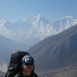
Day 22: Nangkartshang

We woke up at 6 am to a frosty morning, with our window iced over blocking our view out to Ama Dablam. Hauling ourselves out of the warmth of the sleeping bags and into the frigid air, we downed a feast of porridge, omelette, jam toast, fried potatoes and tea for breakfast, before heading out to tackle Nangkartshang. The conditions were once again lovely, and the weather here takes a quite consistent pattern: beautifully clear in the morning and clouding over by mid afternoon without fail, hence our eagerness for an early start.
The 732 m of steep, steep ascent up to Nangkartshang's 5073 m pinnacle was a laboured one, with us stopping regularly to catch our breath in the thinning air and question quite how we could possibly only have ascended about 50 metres each time we'd stopped for a break. Still, the early morning stillness, combined with the peaceful solitude and grand vistas out to some of the largest peaks not only in the region, but also the world, encouraged our efforts. The increased leverage brought us level with some giant glaciers and a great angle of eagle eyed observation over the valley. The views from the vantage point as we broke the 5000 metre barrier were so beautiful in every direction and we agree that they rank among some of the best we've both ever seen. But how were we managing in the altitude? So far, okay. Minus a pang of dizziness from Thomas at the top, which was easily solved with some ibuprofen, we've been doing pretty alright so far (without trying to tempt fate. 🤞) And so, we sat at the mountain's pointy bit for well over an hour, just staring out at the jagged peaks while big birds of prey circled overhead (and Thomas spotted a marmot.)
The route back down was relatively straight forward, and after a spot of lunch, we spent the rest of the day taking it easy, topping up on snacks from a nearby shop and tackling each other's wit with more vicious card games (today I'm the curlywurly. 😔) Thomas also has plenty of fun facts on Edmund Hillary now after having finished his book so hit him up for that if you're feeling nerdy.Baca lagi

PengembaraStill amazing pics to date. Congrats on reaching this far and touching first 5K metres 👏👏
- Tunjukkan perjalanan
- Tambah ke senarai baldiKeluarkan dari senarai baldi
- Kongsi
- Hari 23
- Jumaat, 12 April 2024 6:00 PG
- ☀️ -14 °C
- Altitud: 4,869 m
NepalLobujya27°56’53” N 86°48’38” E
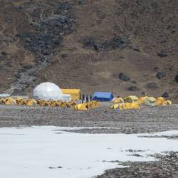
Day 23: Dingboche to Lobuche

We tried to navigate our own way around a lump of earth straight out of Dingboche to avoid climbing it (for no reason other than we're lazy to be honest) and in doing so, accidentally took an unnecessarily indirect route to the start of the path towards Lobuche.
The route which followed was a dusty and gentle incline, but with the altitude it soon became apparent that Thomas was struggling with lethargy and lack of being able to take a satisfying breath. And it's true, everything and anything can tire you out up here and it does make you feel extremely slow. But after he managed to collect some air, we shuffled on towards Thok La pass, negotiating a half-frozen stream set in the moraine on our way. Thok La was the most tiring portion of the day, another upward endurance test where stopping every few steps became basically mandatory. But once we finally reached the top, there were mass monuments to all those who had died on Everest down the years, while the outrageous view from every direction was joined by a new glaciated feature: Pumori peak. With the ground levelling out, we entered the final valley which leads up to Everest Base Camp, and new peaks unfolded as appropriate. Rolling into Lobuche, it's been business as usual in unwinding and recollecting our sanity at a teahouse, this time at an altitude of 4,920 m. If all goes to plan, and we weather the -30°C night (possibly exaggerating but not sure), tomorrow we hit Everest Base Camp.Baca lagi

PengembaraIncredible pictures & surroundings. Look after yourselves & each other.
- Tunjukkan perjalanan
- Tambah ke senarai baldiKeluarkan dari senarai baldi
- Kongsi
- Hari 24
- Sabtu, 13 April 2024 6:00 PG
- ☀️ -12 °C
- Altitud: 5,259 m
NepalKalapathar27°59’54” N 86°50’48” E
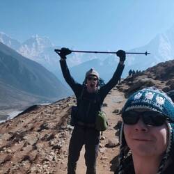
Day 24: Everest Base Camp

Time for a much overdue footprint if phone signal permits. Our experience of Lobuche was relatively pleasant and the night nowhere near as cold as we'd expected.
Our first mission getting going for the day: get to Gorak Shep. Gorak Shep is the highest settlement anywhere before Everest Base Camp at an altitude of 5150 m, where atmospheric oxygen levels are 50% what they are at sea level, so as you can imagine, everything feels a lot more lethargic up there.
This section was split into two parts: the first, a gentle amble up the valley; the second, a tiring scramble up, down, forward, and back over the glacier's scattered scree. After a few draining hours, we reached Gorak Shep and whacked down our big bags into our room, before slumping into the dining room for some lunch. At this point, Thomas confessed his questionable condition (altitude sickness is a bit like that, you can feel decidedly unwell but sort of confused as to how?), while I was also showing some signs of being worse for wear (namely, extreme tiredness and an aggravated cough famously dubbed as the Khumbu cough.) Anyhow, we mustered our strength and decided to push onto Base Camp while we still had the chance.
By this point in the day, the regular afternoon clouds had begun to roll in, and the mild-sounding 2 miles onto Base Camp was beginning to drag, as we again navigated haphazard boulder fields which mounted the glacier. Turning a corner, you get your first glimpse of Base Camp itself, practically a vast city of yellow and orange tents which sprawl precariously all the way up to the Khumbu icefall. With our destination in line of sight, we descended a ridge and just like that, we'd made it!
We afforded some subdued celebrations, hugging each other and enjoying the 5,364 m altitude as our trek's main objective. We then joined the queue (yes, queue) to get a picture with the famous 'Everest Base Camp' boulder and newly installed Hillary and Norgay sign where we commemorated our place under the world's tallest mountain with some quietly pleased pics.
As we still mooched around at Base Camp, the heavy clouds began to spew spatterings of snow down: the start of the 5 cm of snowfall forecast for the afternoon! Fearing a blizzard, we lumbered our way back to Gorak Shep, admiring the surroundings as they turned from snow-dusted to snow-buried. Still, we got back in one piece (or two pieces), tucked away some food, and hunkered down for the coldest night yet: Gorak Shep is so high and so cold that they don't even have water.Baca lagi

PengembaraVy well done 👏👏 A lifetime achievement and a permanent memory for both of u. 🏆🏆 (and i read about a 8yr old hiker also reached Everest Base Camp too! 😳)

PengembaraYes insane! We spoke today about how the youngest person to climb Everest was only 13
- Tunjukkan perjalanan
- Tambah ke senarai baldiKeluarkan dari senarai baldi
- Kongsi
- Hari 25
- Ahad, 14 April 2024 4:00 PG
- ☀️ -12 °C
- Altitud: 5,567 m
NepalKalapattar27°59’44” N 86°49’43” E
Day 25: Kala Patthar

Everest Base Camp may be what everyone sets out to do, but in my opinion, Kala Patthar is the real jewel in the trekking crown. Kala Patthar is a 5,645 m vantage point with gorgeous vistas over mahoosive peaks in every direction. It sits some 300 metres above Base Camp and comes with an even more stark view of Everest unlike any we'd seen before. So with the hour barely 6 am as we departed Gorak Shep, we were delighted to bear witness to the perfect conditions: shimmering snow, unblemished blue skies, and the sun's rays gently easing in the day from over the Himalayan horizon. It was peaceful bliss. Or at least it would've been if not for the punishing ascending altitude we were about to undertake.
As we began our ascent, we were surprised to see other trekkers descending already, at 6 am? That's keen, we thought, as we continued to shuffle our way up the icy incline. Thomas seemed to be coping okay but I've got to say, it was the hardest 'easy' climb I've ever done; wheezing for breath after every few steps and ascending in painful slow motion. I say 'easy' climb because, if not for the altitude, it really should've been. But my god, altitudes that high can be crippling not only on the legs, but on the lungs, and even the brain too, taking sheer determination to stagger to the summit. It had taken us three hours to complete the 500 m of ascent, and our prize: front row seats in an amphitheatre of dramatic snow-capped mountains, headed by its showpiece: Mt Everest, the tallest on Earth. Perhaps ironically though, Everest was probably one of the less impressive views, with Pumori, Lingtren and the nearer Nuptse jarring into the sky, all appearing larger. Still, we lingered on the view out in every direction, and gawped at the climbers' route up to Everest's summit via the wild Khumbu icefall and lumpy Hillary step. Here, we also enjoyed some more enthusiastic celebrations and snapped plenty of photos in the still solitude of the summit. I also got to wave my Kala Patthar hat from the very place it described.
The descent back down was much more brisk, and upon returning to the teahouse, we decided on the first food of the day. I knew something wasn't quite right: I'd felt hungry, but also that I didn't want to eat. Still, I picked away at a pancake and we eventually set off on our way back down. We'd made it barely a few steps out from the front of the teahouse when I then paused to put on my sunglasses, turned, and threw up both violently and repeatedly. Shit. Vomiting isn't a particularly good sign when it comes to altitude, and combined with the symptoms both Thomas and I had been experiencing over the previous couple of days, we decided we needed to take more responsible action and adapt our plans. We had previously intended on attempting the giant Cho La pass over a glacier to Gokyo lake, thus hoping to end today in the village of Dzongla. But feeling rough in ourselves, we instead descended back to Lobuche, where we'd evaluate our plans going forward.Baca lagi
PengembaraFirst mistake was Luton
PengembaraI'd call it a stylistic choice more than a mistake
PengembaraThat was a shaky start 😳
PengembaraIndeed! Worked out ok in the end though, just about!