- Afficher le voyage
- Ajouter à ma liste de choses à faireSupprimer de ma liste de choses à faire
- Partager
- Jour 65
- mardi 14 février 2023 à 06:56
- ☁️ 43 °F
- Altitude: Niveau de la mer
ChiliPunta Arenosa53°7’27” S 70°51’26” W
Magellan Strait to Punta Arenas, Chile

Insignia entered the Strait of Magellan around 7:00p last night to take us to Punta Arenas … our last port of call in Chile.
Although we have not — and will not, for that matter, be transiting the Strait in its entirety, we received certificates anyway.
(Due to the tour we selected for Punta Arenas today, Mui and I are amongst the two bus loads of passengers who did go further into the strait than the rest of the passengers on the ship.)En savoir plus
- Afficher le voyage
- Ajouter à ma liste de choses à faireSupprimer de ma liste de choses à faire
- Partager
- Jour 65
- mardi 14 février 2023 à 12:35
- 🌬 45 °F
- Altitude: 59 p
ChiliIsla Magdalena52°55’10” S 70°34’28” W
The Magellanics of Magdalena Island

We were last in Punta Arenas in 2014. On that visit, we did a private tour to Seno Otway to see the Magellanic penguins, and then spent some time in the city.
We went to see Magellanic penguins again today. But this time we went to Magdalena Island … in the Strait of Magellan … an approximately 1.5-hour boat ride each way.
This tour often gets canceled at the last minute due to high winds and rough seas. Sometimes, even after getting to the island, conditions don’t allow disembarking the boat. Or the return to Punta Arenas is delayed. So, we decided not to chance it on our own and booked the ship’s tour today.
Insignia was docked at Muelle Mardones on the outskirts of Punta Arenas … about a 15-minute bus ride to Muelle Arturo Prat, which is in the city center. Our catamaran was waiting for us at this pier …. right behind Marina, our big sister. A short walk from the bus brought us to the gangway where we were each handed a blue bag and invited to take a seat in one of the two cabins. The booth style seat-table combination was a little tight, but we sat with our friends Norm and Pat and lucked out with the middle seats remaining empty.
Smooth crossing to the island … with a detour to follow some Sei whales (the third largest of the whales) … I counted five puffs and glimpses of the back … two distinct individuals. The motion in the Strait became a little more pronounced the further out we got, but the catamaran handled it well. Nor were the conditions a hindrance to disembarking directly onto the island via a long pier.
No sooner were we on land that it started raining. Actually, it felt more like sleet. The wind also grew stronger, But we persisted and followed the trail that went up to the lighthouse and then looped around back to the shoreline … cutting between the rookeries for the penguins and birds. We were more than halfway around when the rain stopped, the wind diminished, and the sun peeked through the clouds. Hallelujah!
During our walk, we saw small groups of Magellanic penguins … only the ones that are still molting remain on the island at this this time of year; lots of kelp gulls; some Chilean skuas (aka Cinnamon skuas) … fighting over the remains of penguin chicks and gulls; and several pairs of upland goose.
All too soon, it was time to get back on the catamaran for the return trip. On the way to Magdalena Island, we were allowed to go out on deck as long as we wore the life vests we were provided. On the return, we were told to stay inside the cabin. It didn’t take long for the windows to be awash with salt water. Yup … smart to stay inside and munch on the tasty treats that were in the blue bags we’d been given at embarkation.
We were welcomed back to Punta Arenas with a pod of dolphins showing us their agility as they raced the catamaran back to shore.En savoir plus
- Afficher le voyage
- Ajouter à ma liste de choses à faireSupprimer de ma liste de choses à faire
- Partager
- Jour 66
- mercredi 15 février 2023 à 06:10
- ❄️ 32 °F
- Altitude: Niveau de la mer
ChiliCabo de Hornos54°54’30” S 69°25’34” W
Beagle Channel’s Glacier Alley

We are still in Chilean waters, but will soon cross into Argentinian waters.
Before doing so, however we transited the Beagle Channel’s Glacier Alley, which is part of the Chilean Fjords. This section of the waterway is home to 5 tidewater glaciers streaming down from the Darwin Ice Field.
I set my alarm so I could see the one the expedition staff mentioned to Mui last night … the magnificent Italia Glacier.En savoir plus
- Afficher le voyage
- Ajouter à ma liste de choses à faireSupprimer de ma liste de choses à faire
- Partager
- Jour 66
- mercredi 15 février 2023 à 09:09
- ☁️ 36 °F
- Altitude: Niveau de la mer
ChiliRocas Centinelas54°53’17” S 68°20’14” W
Welcome to Ushuaia, Argentina

Stunning! And the snow showers cleared just as we arrived in view of the “End of the World.”
- Afficher le voyage
- Ajouter à ma liste de choses à faireSupprimer de ma liste de choses à faire
- Partager
- Jour 66
- mercredi 15 février 2023 à 18:38
- 🌧 37 °F
- Altitude: Niveau de la mer
ArgentinePunta Observatorio54°48’39” S 68°17’44” W
A Stroll Around Ushuaia

Today was our fourth time in Ushuaia, the city that bills itself as the southernmost city in the world due to its location below 54° South. When we first visited in 2006, it had the tagline “End of the World … Beginning of Everything.” This was once painted on a wall overlooking the bay … now that same wall proclaims Ushuaia as the capital of Islas Malvinas … aka the Falkland Islands.
(Puerto Williams, Chile — closer to 55° South — also claims to be the southernmost city. But it’s population is too small to officially be categorized as a city. At least that’s the Ushuaians’ story and they are sticking to it.)
Two of our visits here were multi-day stays that preceded expedition voyages to Antarctica, and two of them were single-day ports of call. Each time, we found new things to do that we combined with old haunts and favorite restaurants to make a fulfilling visit.
The plan for today was to go hiking. Either up to the much-receded Martial Glacier … or as close to it as we could get. Or over in Parque Nacional Tierra del Fuego.
But then, Mui broke a tooth and we figured that an oft-visited city was a good place to get it repaired. So, off he went to the dentist, arranged through the port agent with a referral from the ship’s medical center.
I suppose I could have found a way to get to the national park and go hiking anyway. Or I could have booked myself on a Beagle Channel cruise. But the changeable weather today — best described as cold, drizzly, windy … in other words yucky — made either an unpleasant prospect. Especially since I’d done both on previous trips.
Instead, I decided to go for a “reminiscing stroll” during which I could duck into a shop, gallery, or café when I wanted a break from the weather … and if I could get into a salon, I could get a haircut too. I could even have lunch at El Turco (the Turk) … our favorite empanada place in Ushuaia. ✔️ ✔️ ✔️. (By the way, we’ve been trying to uncover the source of the restaurant’s name since the first time we ate here in 2006. No one seems to know.)
As luck would have it, Mui finished at the dentist before El Turco closed and was able to join me for a quick bite. Then, we wandered over to Laguna Negra, our favorite artesanal chocolate shop for dessert. Okay, that’s another ✔️. Mui even managed to get into have his hair cut, too … by Fernando, who cut his hair when we were here in 2015.
While, I wouldn’t say that this was our best visit to Ushuaia, we managed to make it a fun and productive one anyway.
Now we head further south … from the “furious 50s to the screaming 60s.” Fingers crossed that Mother Nature treats us gently!
————————————
P.S. one of the collages posted here shows the detail of the stained glass window in honor of Monte Cervantes together with a photo of the tug, St Christopher. The story is too long to relate here, but the tug was involved in the salvage operation for Monte Cervantes. You can search the internet for the sinking of this passenger ship … sometimes referred to as the Titanic of the South.En savoir plus

VoyageurI am so enjoying your blog! And I am so jealous!!! I can’t wait until next February! Stay safe and keep having fun!!!

Two to TravelYou will have a great time. This is nice … but an expedition is so much better.

VoyageurLove your photos! Ushuaia is one of my favorite SA ports of call. Hope Mui’s tooth is good for the rest of the cruise and beyond!
- Afficher le voyage
- Ajouter à ma liste de choses à faireSupprimer de ma liste de choses à faire
- Partager
- Jour 67
- jeudi 16 février 2023 à 14:18
- Altitude: Niveau de la mer
South Atlantic Ocean59°2’54” S 65°7’40” W
Drake Passage: Crossing South

Having been to Antarctica twice, we’ve had the “pleasure” of crossing the Drake three times. Not four, because our 2015 expedition was one-way from the tip of Argentina to New Zealand by way of the Ross Sea.
The first time was not the typical Ushuaia to the Antarctic Peninsula crossing as we went to the Falkland Islands first and then down to South Georgia before crossing to the South Shetlands from there. It was a “Drake Lake” type of crossing. On the way north from the Peninsula to Ushuaia, however … well, it was a doozy of a crossing … a “Drake Shake” with 40 foot waves.
Thus, while many might not agree, I would categorize today’s crossing very close to a “Drake Lake” experience.
Not that it wasn’t rough — very rough — when we left the Beagle Channel behind. In fact, my sleep-fuzzy mind thought that we must already be in the Drake Passage. By all accounts, however, that wasn’t due to happen until around 6:00a. If that was indeed the case, the ship’s movements had moderated considerably by then. Still noticeable with 12-13 foot swells, but nothing like what it was in the wee hours of the morning while we were still in the Pacific Ocean.
So what is this Drake Passage and why is it known for having some of the roughest seas in the world?
The passage lies between the tip of Cape Horn in South America in the north and the Shetland Islands in the south. Back in the day, seafarers called this region, which includes the passage, the “furious 50s and screaming 60s.” But let me also give you the actual Wikipedia explanation … “it connects the southwestern part of the Atlantic Ocean (Scotia Sea) with the southeastern part of the Pacific Ocean, and extends into the Southern Ocean. … Currents at its latitude meet no resistance from any landmass, and waves top 40 feet, hence its reputation as “the most powerful convergence of seas.”
The weather itself wasn’t as cold as I expected it to be. Though not warm enough to sit out on deck — not with the winds blowing as they were. The early morning overcast broke apart for a considerable part of the day. We even had sunshine this morning … and I actually caught Marina spotlighted by the ethereal rays of the sun as it hurried past us around 6:30a. Of course, bigger ship … more powerful engines.
A great start to our Antarctic “expedition by cruise shipEn savoir plus
- Afficher le voyage
- Ajouter à ma liste de choses à faireSupprimer de ma liste de choses à faire
- Partager
- Jour 67
- jeudi 16 février 2023 à 19:38
- Altitude: Niveau de la mer
South Atlantic Ocean61°31’54” S 64°12’26” W
Welcome to Antarctica

We’re still in the Drake Passage tonight … still north of the Shetland Islands … still have a ways to go to reach the Antarctic Peninsula.
But I can welcome you to Antarctica because we passed 60° South … the political boundary for the continent.
We have the certificates to prove it! And a screenshot from the Navigation Channel on the TV that gives our current latitude as 61° South.
Mui and I have been as far south as the Bay of Whales at 78° South … on the Ross Sea Side of the Great White Continent. Definitely won’t be going that far south on this voyage, but getting to anywhere in Antarctica once again gives us untold pleasure.En savoir plus
- Afficher le voyage
- Ajouter à ma liste de choses à faireSupprimer de ma liste de choses à faire
- Partager
- Jour 68
- vendredi 17 février 2023 à 07:32
- Altitude: Niveau de la mer
South Atlantic Ocean63°57’9” S 63°12’40” W
Antarctica: Gerlache Strait

This is out of sequence, but I am putting up what I can … when I can. This far south, the satellite signal is not all that stable. No complaints … look at the wonders around us. They are far more important.
Yesterday, after going to Dallman Bay, we headed to Gerlache Strait and then spent the afternoon in the amazing and spectacular Neumayer Channel … with a dip into the bay where Port Lockroy is situated.
From the map, it looks like we patrolled Gerlache Strait overnight. That’s a good thing as it means we didn’t miss much once night fell. Yes, it actually gets dark here this time of the year.
Today’s destination, unless plans change is very near the blue dot that marks our current position.
P.S. Fret not … I will catch up with photos for yesterday. I am in one of my favorite (if not “favoritest” (yes, I realize that is not a real word) part of the world and I would rather live the moment than process photos.En savoir plus

VoyageurGoosebump area for me as well. We went to Antartica (full expedition) in 2008 for our honeymoon. Will never forget it - I could "process" this raw and overwhelming beauty only with tears in my Eyes!

Two to TravelAgree full heartedly … we’ve been so blessed to be able to come down here on expedition trips in the past. I will say that I didn’t expect that Insignia would be able to give us a “close” experience. She delivered yesterday. We’ll see what today has in store for us.
- Afficher le voyage
- Ajouter à ma liste de choses à faireSupprimer de ma liste de choses à faire
- Partager
- Jour 68
- vendredi 17 février 2023 à 11:08
- Altitude: Niveau de la mer
South Atlantic Ocean64°28’31” S 63°2’4” W
Antarctica: Dallman Bay & Gerlache

Day 1 of Antarctica cruising …
Woke up to rain — which, on closer examination, turned out to be snow. Fog and wind. And cold 🥶
Hmmm! “Where is the better weather conditions that brought us to Dallman Bay?” I thought. After all, that’s what Stephanie, the leader of the expedition team, had given as the reason for heading further south than originally intended.
Of course, this is Antarctica and the weather is known to turn on a dime. We know this from experience. So, we grabbed a bite to eat, bundled up in our layers, and went up to the outside decks on 10 and 11 to roam about and see what we could see.
Which was actually quite a bit. Icebergs floating by on the currents. Bergy bits and growlers bobbing on the water. Glaciers and mountains partially hidden by the fog. I took what is for me a limited number of photos since the distant scenery was pretty much socked in. But the nearby icebergs made up for what we couldn’t see in the distance.
In terms of wildlife — Antarctic fur seals, whales, Antarctic terns and fulmars on the wing, gentoo penguins … both rafting and porpoising. I took a few snapshots of the critters, but I have such a large collection of photos of them from expedition voyages to the area that I am opting not to focus too much on trying to capture wildlife images on this cruise. “Enjoy their presence and the setting around me” … that is my motto for the next several days.
One of the more delightful aspects of the morning, actually, was seeing the crew playing in the snow. For many, it was their first time encountering this type of precipitation. Seeing their almost child-like glee as they ran around the pool deck having snowball fights, taking photos to share with family back home, writing their names or messages where they found a bit of accumulated snow. It was terrific fun.
With what Stephanie described as the “atmospheric mood” of Dallman Bay not looking like it was going to clear up, the decision was made to leave and check out another spot. To do so, we had to cruise down the Gerlache Strait for a bit.
The conditions weren’t much better … at first.
And with that teaser, I’ll wrap up this footprint …En savoir plus
- Afficher le voyage
- Ajouter à ma liste de choses à faireSupprimer de ma liste de choses à faire
- Partager
- Jour 68
- vendredi 17 février 2023 à 16:38
- ☁️ 32 °F
- Altitude: Niveau de la mer
AntarctiqueEcheverry, Ensenada64°49’9” S 63°33’24” W
Antarctica: Neumayer Channel

While Antarctica might not be new to Mui and me, there are still many parts of it that we have not been to. The Neumayer Channel isn’t one of them. But we are counting it as good as new to us. You see, when we sailed through the channel in 2007, it was so socked in by thick fog that we did not see anything.
We were already on deck 10 around 2:00p when Insignia approached the entrance. It was still overcast … low lying clouds wreathing the tall mountains. But there was a brightness to the afternoon light that gave us hope that we’d be seeing some sunshine. We did … and patchy blue skies, too. Perfect!
There were a surprising number of ships in the Neumayer Channel … a big change from when we were here in 2007 … and even in 2015. Back then, we rarely saw another vessel as we explored the Great White Continent. That Antarctica’s popularity is growing in leaps and bounds was proven by the presence of the vessels. (That’s not necessarily a good thing, but I won’t get on my conservation box.)
Wildlife once again made their appearance during our time in the Neumayer Channel. Yes, there were gentoo penguins … on shore and porpoising through the water. Yes, there were whales. We also saw some seals — two crabeater seals … one of which was quite close to the ship; and a leopard seal … one of the two predators in the Antarctic.
Frankly, Mui and I were expecting that we’d be seeing things from a much farther distance! Captain Stjepan and his bridge team, with the advice of the ice pilot and Stephanie, the leader of the expedition team, did an amazing job of getting us through the channel and “safely” close to what we came here to see … Stupendous Antarctica!
P.S. We are especially grateful that Captain Stjepan was willing to dip into the bay where Port Lockroy is situated. It was fun to get a glimpse of the places we roamed when we landed here in 2007 … and then were rushed back to the ship early because of a fast-moving storm moving in unexpectedly.En savoir plus

VoyageurAbsolutely fabulous photos. You’ve had great weather it seems. And you have a good eye for taking memorable photos!!
- Afficher le voyage
- Ajouter à ma liste de choses à faireSupprimer de ma liste de choses à faire
- Partager
- Jour 68
- vendredi 17 février 2023 à 20:13
- ☁️ 32 °F
- Altitude: Niveau de la mer
South Atlantic Ocean64°55’24” S 63°17’24” W
Antarctica: Evening in Gerlache Strait

It gets dark in Antarctica this time of the year … for a number of hours at least.
Mui and I are not used to having actual nightfall down here. Then again, we’ve never been here this late in the Antarctic summer. No matter, we’re usually getting ready for bed around 10:30p when the sun finally sets. Sunrise is around 5:30a … just a little before we wake up.
I don’t mind the nightfall. On previous trips, with it still being light and bright even at midnight and beyond, I found it hard to leave the open decks because I didn’t want to miss anything. On this trip, I’ll be getting a good night’s rest after the scenery is shrouded by nightfall.
All that said, as we cruised Gerlache Strait tonight, we did take advantage of the daylight after dinner to enjoy some of the best scenery we saw today … sunlight, blue skies … makes all the difference.
Tomorrow’s cruising destination is not far from here. So, I’m thinking we won’t be straying far tonight.En savoir plus
- Afficher le voyage
- Ajouter à ma liste de choses à faireSupprimer de ma liste de choses à faire
- Partager
- Jour 69
- samedi 18 février 2023 à 09:25
- Altitude: Niveau de la mer
South Atlantic Ocean64°46’16” S 62°52’34” W
Antarctica: Danco Coast

I suppose this could be considered a summary of where we spent our second day in Antarctica … along the Danco Coast, exploring nooks and crannies of some of the most beautiful parts of the world.
Plans to go into Paradise Bay were foiled by ice. So we explored Andvord Bay and squeezed through Errera Channel instead.
Despite what our expedition leader calls “atmospheric Antarctic weather”, we had a wonderful time on deck. Hence, the photo footprints shall follow at a later date.
Oh, and yes … a whale fest seemed to be following us everywhere we went. Thank you GM Claudio for ordering up 12 whales for us. They must have sent word to their friends to join them, too! Nice to see the order was not messed up due to supply chain issues 😉🤣
To wrap up the day … a RTW special dinner at Polo with beautiful views of Gerlache Strait through the rain streaked aft windows as we began the transit north from the Peninsula.En savoir plus
- Afficher le voyage
- Ajouter à ma liste de choses à faireSupprimer de ma liste de choses à faire
- Partager
- Jour 69
- samedi 18 février 2023 à 10:26
- ☁️ 28 °F
- Altitude: Niveau de la mer
South Atlantic Ocean64°47’59” S 62°43’21” W
Antarctica: Andvord Bay

Mui and I were looking forward to returning to Paradise Bay … one of our favorite places in Antarctica … near where we made our first continental landing in 2007.
Alas, it wasn’t meant to be. There was too much ice at the entrance … Insignia is not ice-hardened. And we presented too big of a sail for the wind that was blowing at 22 to 30 knots.
Instead of sticking around just because Paradise Bay was the listed “destination” for today, we moved on to Andvord Bay … to make the best of what the Antarctic gods handed us … in true expedition style.
It was a mostly B&W sort of day, but we enjoyed amazing, larger-than-life polar scenery, passing some of the largest icebergs of our trip thus far. We also saw plenty of gentoo penguins rafting by on large bits of ice … close enough to clearly identify them.
But the highlight had to be the “whale fest.” It seemed like they were all around us … mostly humpbacks and a couple of minkes. They showed us some amazing feeding behavior … often in quite close proximity to Insignia. In fact, Mui got our best whale footage to date when a humpback surfaced next to the ship and went about feeding as though we didn’t exist in its universe. (Alas, the file is too big to share on FindPenguins, so the short snippets I took with my iPhone will have to suffice.)En savoir plus
- Afficher le voyage
- Ajouter à ma liste de choses à faireSupprimer de ma liste de choses à faire
- Partager
- Jour 69
- samedi 18 février 2023 à 13:31
- ❄️ 30 °F
- Altitude: Niveau de la mer
AntarctiqueSherlac Point64°45’9” S 62°39’35” W
Antarctica: Errera Channel

From Andvord Bay, Insignia repositioned to Errera Channel. The timing was perfect … lunch time … we went to the Terrace Café so we could continue to enjoy the scenery. For the second day in a row, soup looked to be the most popular item at the buffet.
A little before 1:00p, Expedition Leader Stephanie came on the P/A to tell us that Captain Stjepan was going to maneuver the ship to pass close to a big iceberg … probably the biggest one we’d be seeing on our journey through Antarctic waters. It was a beautiful piece of ice … big enough that one has to wonder at the size of the glacier that would have given birth to it … must be massive beyond words.
Our cruise through Errera Channel started off well enough. Stupendous scenery … as we have come to expect. But it wasn’t long before the mountain tops became veiled by fog. Then, it started to rain and sleet. The wind began to howl.
Suddenly deck 10 was deserted. I’m guessing that people sought shelter … in the Horizons Lounge (which has been packed since we began our scenic cruising yesterday) or in their cabins. Mui and I picked up some hot chocolate, broke out the hand warmers, and sat in the protected corner of deck 10 where there are four chaise lounges. Every once in a while, someone came out on deck … but for the most part, we had the place to ourselves. Total solitude. Silent … except for the wind screaming down the staircase that goes up to deck 11. No matter … we were cozy where we were … and loving every minute of the experience.
We passed by some penguin rookeries on shore. We saw some seals and whales in the water in the Errera Channel. But I’d have to say that Andvord Bay won the wildlife award today hands down.
Around 4:00p, with no indication that the weather was going to let up, we decided to go to our cabin. Time to get ready for tonight’s special event for RTWers … at least some of them.En savoir plus
- Afficher le voyage
- Ajouter à ma liste de choses à faireSupprimer de ma liste de choses à faire
- Partager
- Jour 69
- samedi 18 février 2023 à 18:26
- ❄️ 30 °F
- Altitude: Niveau de la mer
AntarctiqueHobbs Point64°38’10” S 62°0’33” W
Antarctica: RTW2023 Dinner

We fondly remember the special dinners we enjoyed on RTW2017. With around 250 passengers then, there was no problem seating everyone in the Polo Grill and Toscana on the same night … at tables of 6-8 … hosted by junior and senior officers … delicious food … wine flowing freely.
With nearly 400 RTWers on this voyage, it is no longer possible to gather everyone together on the same night. So, the dinner is being held on two separate nights. From what I gathered, the passengers are broken down by deck … an equitable arrangement.
We were greeted on the staircase by Chase, who is a member of the Insignia Show Band, and Ilya, a production cast dancer. The officers were all lined up outside the Polo Grill to welcome us and hand us off into the capable hands of the Polo team.
(The start time for the two groups was staggered, so I’m pretty sure the same welcome was extended to those invited to Toscana at 7:00p.)
The food was delicious … the wine flowed freely. We were at a table with our friends, Sonia & Boris … overlooking the aft of the ship … watching the Antarctic scenery pass by behind the rain sheeting down the windows as we enjoyed our meal.
We had a very nice evening and look forward to more of these dinners as the voyage progresses.
(By the way … no officer hosts tonight. If the reason I heard is true, then we — the passengers — have no one to blame but ourselves. And that’s all I am going to say on that topic.)En savoir plus
- Afficher le voyage
- Ajouter à ma liste de choses à faireSupprimer de ma liste de choses à faire
- Partager
- Jour 70
- dimanche 19 février 2023 à 06:22
- Altitude: Niveau de la mer
South Atlantic Ocean63°11’37” S 60°45’29” W
Antarctica: South Shetland Islands

My third — and what should be the final — out-of-sequence summary posting for the Great White Continent.
We’re still below 60° South … so today’s cruising was still in Antarctic waters. But we moved away from the Antarctic Peninsula last night to spend the day in the South Shetland Islands.
These are the same islands that form the southern boundary of the Drake Passage. But by staying on the south side of the archipelago, we avoided getting into the Drake. That will happen sometime this evening as we make our way north.
Our exploration of the islands started with Deception Island … moved onto Half Moon Island … passed by Greenwich Island and Yankee Harbor, and concluded in Admiralty Bay at King George Island.
Yes, photo footprints will be forthcoming. We have some days at sea before and after the Falkland Islands. So, if the internet signal cooperates, you should start seeing some postings tomorrow.En savoir plus

VoyageurDid you do any landings? Or just scenic cruising also because of the ice 🧊?

Two to TravelYou mean made landings on Insignia? No landings … a ship this size and with so many pax is not allowed to do landings. Strictly drive-by anywhere in the Peninsula and nearby islands. No piers for tenders that I can think of.

Voyageuryes, you are right. restrictions to max. 100 PAX at the time. and tge landings are done only with Zodiacs, no piers anywhere. still a beautiful adventure and a challenge for the Captain since the ice can be dangerous

Two to TravelWe are so happy to have Captain Stjepan for this segment. He listened to the advice and suggestions of the expedition leader and ice pilot and took us much closer to the scenery than we were expecting to be able to get on a cruise ship.

VoyageurThis is fantastic to hear! I am so happy for you & for us since your great footprints are allowing us to join you! Really appreciate your efforts with all your blogging! 🙏🙏

Two to TravelMy pleasure … a little behind now, but hopefully will be caught up by tonight. What can I say, I’d rather live the moment when I have a chance to do so.
- Afficher le voyage
- Ajouter à ma liste de choses à faireSupprimer de ma liste de choses à faire
- Partager
- Jour 70
- dimanche 19 février 2023 à 08:14
- 🌬 37 °F
- Altitude: Niveau de la mer
AntarctiquePetes Pillar62°59’45” S 60°31’49” W
S Shetlands: Deception Island

We’re still in Antarctica … but we have moved away from the Antarctic Peninsula to the South Shetland Islands.
Although the itinerary didn’t list it, our morning started at Deception Island … what remains of a strato volcano. It was so named by Palmer, an American sealer, because of its outwardly deceptive appearance. What looks like an island has an entrance — albeit a narrow one — that allows access into what is actually the collapsed caldera of the still-active volcano.
Deception Island is a popular expedition stop within Bransfield Strait. Twice now we’ve gone through Neptune’s Bellows — the break in the caldera wall — to the black sand beaches in the interior. Anchoring off Whaler’s Bay, we’ve hiked up the scree to Neptune’s Window — which looks like a giant took a bite out of the caldera wall — and looked out.
(For anyone interested in seeing what is inside the caldera, this link will take you to the post I wrote when we landed at Deception Island in 2015 … https://2totravel.blogspot.com/2015/06/deceptio….)
Today, we stayed outside the caldera. Raven Rock, submerged in the middle of Neptune’s Bellows, made it impossible for Insignia to enter … we are just too big. Instead, we sailed around the outer edge … seeing Deception Island from a different perspective. We cruised past the Bellows and caught glimpses of the interior from Neptune’s window. We passed the 100,000-pair strong breeding colony of Chinnies (chinstrap penguins) reaching high into the hills at Baily Head, which has been identified as an Important Bird Area. There were some Antarctic fur seals in the water … just tiny dots.
Deception Island was wreathed in low-lying clouds when we first arrived, so I didn’t even attempt to go out to the public decks. I didn’t really need to. Insignia passed the island on the port side. I just threw on a few layers over my fleece PJ pants and watched everything slide by from our veranda. As we moved along the coast, the low-lying clouds started to move up and we ended up getting some good views.En savoir plus
- Afficher le voyage
- Ajouter à ma liste de choses à faireSupprimer de ma liste de choses à faire
- Partager
- Jour 70
- dimanche 19 février 2023 à 10:58
- Altitude: Niveau de la mer
AntarctiqueMatamala, Caleta62°35’12” S 59°52’38” W
S Shetlands: Half Moon Island

We had a one hour break between Deception Island and our second cruise-by location in the South Shetlands … Half Moon Island.
Half Moon Island, which consists of a series of gravel bars, is so named due to its crescent shape. It is thought to be an eroded caldera much older than Deception Island.
I remember that when we called here in 2015, the zodiac landing had to be moved to the other side of the island due to the sea state. And then we trekked across to the primary landing site to be picked up by the zodiacs to return to the ship. This required a special permit to cross what is another Important Bird Area [IBA] and we were instructed to keep walking and not stop for long periods of time so as not to adversely impact the study being undertaken of the nesting ares of south polar skuas, Antarctic terns, snowy sheathbills, kelp gulls, and a variety of petrels.
When we first arrived today, the low lying island was practically enveloped by fog. Luckily for us, visibility improved as we got closer. In fact, we were able to see the huts of the research station, near which the Hanseatic Spirit was landing its passengers.En savoir plus
- Afficher le voyage
- Ajouter à ma liste de choses à faireSupprimer de ma liste de choses à faire
- Partager
- Jour 70
- dimanche 19 février 2023 à 11:40
- ☁️ 36 °F
- Altitude: Niveau de la mer
AntarctiqueWulfila Glacier62°33’10” S 59°46’28” W
S Shetlands: Greenwich Island

Across from Half Moon Island, which lies within the protection of Livingston Island, is Greenwich Island. On the way out of the strait that lies between them, we were given a close up sail-by Yankee Harbor and Greenwich Island to enjoy the scenery … appreciated all the more because visibility had improved considerably. Since the scenery was on the port side, we were able to enjoy it all from the comfort of our own veranda.
When Stephanie announced that it would be approximately 2:00p before we reached our next destination, we unbundled and went up to the Terrace Café for lunch. At the entrance, we were told that to ease the overcrowding, Toscana was open as an extension for “bring-your-own-food-from-the-buffet-lunch-with-a-view.” Quiet and peaceful … especially in the aft section.En savoir plus
- Afficher le voyage
- Ajouter à ma liste de choses à faireSupprimer de ma liste de choses à faire
- Partager
- Jour 70
- dimanche 19 février 2023 à 16:15
- Altitude: Niveau de la mer
South Atlantic Ocean62°9’35” S 58°22’39” W
S Shetlands: King George Island

Around 2:00p, Expedition Leader Stephanie was back on the P/A to advise us that we were approaching Admiralty Bay on King George Island … the largest of the land masses that make up the South Shetlands.
We’d been able to enjoy the sights of the South Shetlands this morning from our veranda because there was nothing but open water on the starboard side of the vessel. That was not going to be the case this time. So, we bundled up and went up to deck 10, adding extra layers as the wind was downright brutal … especially when Insignia was changing its heading.
I found the scenery as we entered the Ezcurra Inlet quite interesting. On the port side — as we passed Arctowski, the Polish research station — the land was stark … no ice … no noticeable vegetation. Just rocky outcroppings. On the starboard side, however, the Emerald Icefalls streamed down from between the mountains. Some of them reached the water, retaining their tidewater designation. Others had retreated to land. It was an amazingly beautiful landscape. We didn’t go too far into the inlet before Insignia turned its bow around to explore other parts of the bay.
Stephanie described King George Island as a mini United Nations. Apparently there are 10 or so different countries with research stations established on the island … some of them operating only during the summer. In addition to the Arctowski station, we also passed by the Brazilian station — Commandante Ferraz — in the Martel Inlet where we saw the Stenhouse Glacier and the Ajax Icefall.
When Insignia turned its bow towards Admiralty Bay again to retrace its route to get out to the Bransfield Strait, the wind picked up again. We’d been having trouble keeping our cameras steady, now it was impossible. Standing upright was a challenge, too. We bid goodbye to the landscape and went indoors.
Due to the scenic cruising we’ve been doing, some of the activities that usually take place in Horizons have been relocated to other venues. For example, the Coffee Chat and Needle Point is held in the Insignia Lounge. The Afternoon Tea Time is in the Terrace Café … complete with the quartet providing music. To warm up a bit after our time out on deck, we stopped into the afternoon tea. Actually, Mui got some ice cream for himself … I enjoyed the tea and assorted treats. Not the same ambiance as in the Horizons Lounge. But that’s OK. The ambiance was outside the window.
Thus we have completed the Antarctica portion of our world cruise. Now, having rounded Cape Melville, we’re rockin’ our way around King George Island to enter the Drake Passage for our northbound crossing.
I wonder if the Drake will treat us to a lake or to a shake this time?En savoir plus
- Afficher le voyage
- Ajouter à ma liste de choses à faireSupprimer de ma liste de choses à faire
- Partager
- Jour 70
- dimanche 19 février 2023 à 18:36
- 🌬 37 °F
- Altitude: Niveau de la mer
South Atlantic Ocean61°51’12” S 57°17’6” W
Antarctica Summary Map

A quickie map showing our route through Antarctic waters.
I still believe that the best way to experience Antarctica is by stepping on land … walking amongst the critters … getting truly up close and personal with the icy landscape … coming within touching distance of seals and whales on zodiac cruises … meandering around an iceberg graveyard during the golden light of midnight.
That said, Insignia’s bridge team, under the command of Captain Stjepan, and with the guidance of our ice pilot and expedition leader, gave us an Antarctic experience that far exceeded our expectations of a drive-by cruise. We will remember these three days fondly as part of our RTW voyage.
So, I will say to those who have yet to experience Antarctica what I always say when asked if the cost of an expedition is worth it? Absolutely. But it depends on your level of interest. If you’re infected by the “ice virus,” like we were on our first journey to these latitudes, you will not regret either the cash outlay or the time you must invest in an expedition. But if you have only a glancing interest in all things polar, than you will likely be satisfied with a drive by experience. Regardless of which option you choose, come down on as small a vessel as you feel comfortable sailing. You won’t regret it.En savoir plus
- Afficher le voyage
- Ajouter à ma liste de choses à faireSupprimer de ma liste de choses à faire
- Partager
- Jour 71
- lundi 20 février 2023 à 20:44
- 🌬 48 °F
- Altitude: Niveau de la mer
South Atlantic Ocean53°59’17” S 57°30’31” W
Drake Passage: Crossing North

The Drake Passage, infamous for its 40-foot waves and howling winds, once again treated us to a “Lake” rather than a “Shake.” The sea state was no more than 10 feet for much of the day. That there was sunshine and blue skies, too, made for a delightful crossing north.
Yes, it is still on the chilly side, but no complaints. We’ll be in hot temperatures soon enough and it won’t be long before we’re complaining about the opposite spectrum of the temperature gauge.
We had a quiet day … a lot of reading … a lot of writing and photo processing to get some of the Antarctica footprints caught up.
I carved out time to go to Dr Andrew Atkin’s (Antarctic expedition team historian) presentation on “Scott, Amundsen, and the South Pole.” It was a comparison of the expedition styles of the two men. I must admit that I am in the “Amundsen camp” on this one. I am looking forward to his presentation on Shackleton on our next day at sea.En savoir plus
- Afficher le voyage
- Ajouter à ma liste de choses à faireSupprimer de ma liste de choses à faire
- Partager
- Jour 72
- mardi 21 février 2023 à 07:49
- 🌬 54 °F
- Altitude: Niveau de la mer
Îles FalklandNavy Point51°40’41” S 57°49’52” W
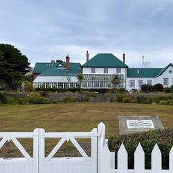
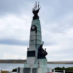
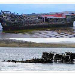
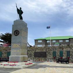
Welcome to Stanley, Falkland Islands

With this post, I am going to turn our day on its head and start from what we did last — a stroll around Stanley. Why? Simple … the images from around the city are a more appropriate means of welcoming readers to the capital city of the Falklands Islands.
On our way back to the tender pier after our tour, our driver, John, gave us a quick drive-by of some of the sites on the outskirts of downtown Stanley … showing us the skeletal remains of whales, memorials, and a few other things. We found the city to be much expanded since we were here in 2007. Even the small museum we had visited then had been relocated to a larger facility.
The one thing that had seemingly grown smaller was the wreck of the Jhelum, a ship that was launched in Liverpool in 1849. It was damaged going around Cape Horn while carrying guano from Peru to France. The Jhelum “limped” into Stanley Harbor for repairs and was eventually deserted by the crew. From what John said, the reason there is so little of the wreck left since we saw it in 2007 is the worms that are eating the wooden hull.
After we were dropped off at the tender pier, we went for a “reminiscence stroll” near the waterfront. We visited Christ Church Cathedral with its beautiful stained glass windows and an iconic arch on the grounds … made from the jawbones of two blue whales; went into a supermarket to see if we could find some McVities chocolate (no luck); and wandered along some of the back streets, looking for the shop from which we bought woolen goods last time (closed, alas).
Our stroll completed, we returned to the tender pier by way of The Globe, one of the pubs in Stanley. No time to sit down for pub fare, but at least we got a snapshot of it with one of the iconic British phone booths.En savoir plus
- Afficher le voyage
- Ajouter à ma liste de choses à faireSupprimer de ma liste de choses à faire
- Partager
- Jour 72
- mardi 21 février 2023 à 11:06
- 🌬 57 °F
- Altitude: 56 p
Îles FalklandVolunteer Beach51°28’49” S 57°50’3” W
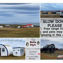
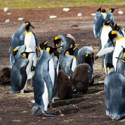
Falklands: Volunteer Point

YAY! We made it ashore.
We had a 50/50 chance of being able to do so, but the weather gods favored us today. But you already know that we were able to tender into Stanley because I turned the day on its head and started from the end of the day. Now for the first part of our day.
Our luck followed us ashore and we managed to get on the first tender to begin our exciting adventure.
I am of the ilk that believes that there is no such thing as seeing too many penguins. In 2007, we visited Gypsy Cove where a colony of Magellanic penguins nest. So, today we went to Volunteer Point to see not one, but three species of penguins — the kings (next largest after the emperors), gentoos, and Magellanics.
Volunteer Beach is an Important Bird Area. It was named for a ship by the same name that called on the Falklands in 1815. The nature reserve is located on the Johnson’s Harbour Farm. Established in 1870, this 52,000-acre sheep property is the largest surviving farm that is still privately owned. I understand that the owner charges an entry fee that is included in the tour cost.
To get to the beach, Mui and I joined a public tour operated by Patrick Watts. There are other operators who do the same tour, but his name seems to be synonymous with Volunteer Point. The trip requires a 4WD to get out to the beach … with good reason.
Normally, four people are squeezed into each vehicle. But we lucked out. Robert, a segment passenger on Insignia, was traveling solo, so the vehicle we were assigned to had just the three of us. Thank goodness … it would have been an incredibly uncomfortable ride otherwise.
I’m not sure what the distance was to get out to the beach. It doesn’t matter really because the terrain is such that the last 10 km or so took us about 1.5 hours to accomplish. With our driver, John, at the wheel, we started out on the paved roads in Stanley. Then we connected to a dirt road for the remaining distance to the farm. Here we had a potty break. And also took advantage of the “Bake Safe” to get ourselves a couple of the most delicious cherry muffins we’ve eaten in a very long time.
And then the adventure to get out to the beach began in earnest.
We went bumpity-bump-bump over boggy terrain covered with grass, clumps of tussock, and diddle-dee berry bushes (the latter is an acquired taste). We went up steep hills. Down even steeper hills. Crossed heavily rutted, wet ground where boards were placed over heavier run off water to ensure we didn’t get stuck in the mud. There were five gates that we had to open and close. That job fell to the first and last vehicle. We were in the middle of a convoy of 6 4WDs … traveling together for safety reasons.
It was interesting to watch the vehicles doing a dance of sorts as we moved further onto the farmlands, jiggling this way and that … but always courteously maintaining their position in the convoy. Along the way, we passed herds of sheep staring at us … perhaps wondering why on earth we were putting ourselves through the gyrations of going out to the beach.
(I’m uploading a video of the 4WD portion of the drive, but it does not reflect how bumpy it was because the camera has built-in stabilization that eliminated the worst of the shake.)
Finally, about 2.5 hours after leaving Stanley, we arrived at Volunteer Beach. It was now getting on towards 11:00a. After a quick stop to swish our shoes in a special solution to kill any invasive species, we parked in the area set aside for the vehicles … very neatly organized, with each tour operator having its own designated space.
John gave us the basic rules — don’t cross into roped off areas; don’t step inside areas encircled by rocks painted white. That’s it. We were then free to roam amongst the penguins, maintaining a 20 foot distance from all wildlife. But the penguins could approach us. Which they did with equanimity … going about business as usual as though we did not exist.
The kings and gentoos are apparently at the reserve year round, and we saw plenty of them. They are 4,000-strong, including 600-700 chicks reared annually. The other two species are in the thousands. The Magellanics migrate, and we saw just a few of them … mostly those waiting to complete their annual molt so they could swim away to points north. We were OK with that since we’d been to a Magellanic colony in Punta Arenas. There were also Falkland skuas, upland geese, dolphin gulls, South American terns, and ruddy-headed geese, Except for the upland geese, they were all at a distance, so we did not see much of them.
We had 1.5 hours at Volunteer Point and spent most of that with the king penguins in their nest area. Yes, it stunk to high heaven, but the wind was blowing strong — and getting stronger by the minute. By positioning ourselves downwind, we minimized the assault on our olfactory senses. It was wonderful to see chicks at different stages of growth amongst the adults. No eggs, however, as the incubation period, for the most part, is between December and January.
Eventually, we left the kings to go down to the beach where we saw the gentoos. By this time, the wind was blowing so strong that the white sand looked like the beginnings of a blizzard. The gentoos were hunkered down and gave us some nice photo ops. Soon, some of the kings made their way to the beach. They were fairly clean, so I imagine they were some of the “bachelors and bachelorettes” we saw in a small cluster. They waddled their way to the shoreline, looking like they were trying to decide if they wanted to go hunting for food. They were still there when we finally had to leave to return to the vehicle.
John had picked up lunch bags for each of us. We ate our egg salad sandwiches, chips, and sweet treats as we went bumpity-bump-bump back to the farm. A dirt road never looked as good as it did today!
The adventure of getting to Volunteer Point was definitely worth it for the up-close penguins we saw today. Hands down the best tour yet!En savoir plus

VoyageurThe trip to Volunteer Point is something! On the day we visited my iPhone health app registered that I climbed 92 flights of stairs just from the bouncing on the off-road drive! Glad the weather cooperated so you could stop in the Falklands…although that blowing sand looked wicked!
- Afficher le voyage
- Ajouter à ma liste de choses à faireSupprimer de ma liste de choses à faire
- Partager
- Jour 72
- mardi 21 février 2023 à 19:00
- 🌬 55 °F
- Altitude: Niveau de la mer
South Atlantic Ocean51°36’51” S 57°38’47” W
Itinerary Change #15

The news came to us in the form of a letter that was in our cabin tonight.
We lost Vitória, Brazil due to complications with the port accepting cruise ships. It was to have been a new-to-us port.
But we gained an overnight in Bahia de Salvador, another new-to-us port in Brazil.
No complaints.En savoir plus