


Day 49.5 Dinas Mawddwy to home
 July 3 in Wales ⋅ ☁️ 18 °C
Spent a sunny morning at campsite laying out clothes to dry. Fortunately I had a bench beside my pitch to use. Clothes had dried by the afternoon but Boots were still wet from yesterday's 'dip' in aRead more


Day 49 Bwlch Llyn Bach to Dinas Mawddwy
July 2 in Wales ⋅ ⛅ 16 °C
Thursday: Up 06:40 away 10:00
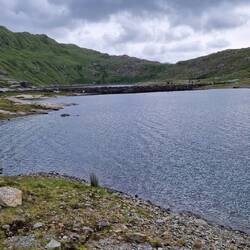
Late start today. I had to wait for the campside office to open to collect my Power bank that they had charged overnight. Also to wait for the Cader Idris Outdoor GearRead more


Day 49c Cribin Fawr, Craig Portas, Maesglase
July 2 in Wales ⋅ ☁️ 17 °C
Thursday: Photographs as I progressed further east along the ridge.


Day 49b ascent to Waun-oer
July 2 in Wales ⋅ ⛅ 17 °C
Thursday: A mile along the ridge reached the 607m summit of Waun-oer. A few photographs along the way.


Day 49a Leaving Bwlch Llyn Bach
July 2 in Wales ⋅ ☁️ 16 °C
Thursday: A few photographs from my ascent up from my start point at Bwlch Llyn Bach to the ridge I would hike along for the day, which I gained between Mynydd y Waun and Mynydd Ceiswyn.


Day 48 Pant y Cae to Bwlch Llyn Bach
July 1 in Wales ⋅ ☁️ 17 °C
Wednesday: Up 05:30 away 07:50
Retired 20:30 last night so up very early this morning as a result. Early morning forecast was rain from 07:00 so I got a move on striking and packing camp. Even thoughRead more


Day 47 Barmouth to Pant Y Cae campsite
June 30 in Wales ⋅ ☁️ 17 °C
Tuesday: Up 06:00 away 07:20
Resuming my walk today after 14 days waiting for weather to improve. Having first been too wet, then too hot with highs of 38C. Now it is goldilocks weather, just right.Read more


Day 46 Llyn Hywel to Barmouth
June 16 in Wales ⋅ ☁️ 17 °C
Tuesday: Up 06:00 away 11:38
Foggy morning and forecast not encouraging so decided to walk up and down Rhinog Fach lightly loaded leaving pitch setup. Outline plan was to abandon walk to Barmouth,Read more

Day 45 Llyn Du to Llyn Hywel
June 15 in Wales ⋅ ☁️ 19 °C
Monday: Up 07:36 away 11:30
Rain during the small hours but glorious when I got up. Tent was dry already and ground sheet was dry. Glad to learn I had suceeded in picking a dry spot.
Very lazy startRead more


Day 44 Trawsfynydd to Llyn Du
Jun 14–18 in Wales ⋅ ☁️ 15 °C
Sunday: Up 07:30 away 10:20
Late start today while I laid out tent and sleeping mat to dry out in the sun.
Inspired by Dave Taylor's suggestion (of Barmouth walking festival) that I might beat theRead more


Day 43 Cardiff to Trawsfynydd
June 13 in Wales ⋅ ☁️ 14 °C
Saturday: Up 06:30 away 09:20
Up early to finish packing my rucksack. Walked 10 minutes to bus stop to catch my first bus of 4 buses. Last bus will drop me outside Trawsfynydd village from which IRead more


Day 42 Maentwrog to Trawsfynydd
July 10, 2023 in Wales ⋅ 🌧 17 °C
Monday : Up 07:00, away 09:15.
Dry as I began striking camp and packing. Rain started as I struck tent. Walked the mile to Maentwrog, where I met my friend Dave from Barmouth Walking Festival, whoRead more


Day 41 day off in Maentwrog & Porthmadog
July 9, 2023 in Wales ⋅ ☁️ 17 °C
Sunday : Up 08:00, away 09:10.
Slept later than I intended, presumably tired from lack of sleep yesterday. Skipped breakfast and started walk to Maentwrog for 10:00 Service at St.Twrog's. I was aRead more


Day 40 Cnicht to Maentwrog
July 8, 2023 in Wales ⋅ ☁️ 16 °C
Saturday : Up 06:00, away 07:00.
Wind strength was unbelievable during the night. Tent was continually flapping violently against my sleeping bag. I felt sure my Terra Nova Wild Country Zephyros 1Read more


Day 39 Pont Bethania to Cnicht
July 7, 2023 in Wales ⋅ ⛅ 22 °C
Friday : Up 07:00, away 09:00.
Struck camp without breakfast so I could eat in nearby Caffi Pont Bethania. Cambrian Way then continued alongside Llyn Dinas lake. Passed a couple of Duke of EdinburghRead more


Day 38 Pen-y-pass Snowdon Pont Bethania
July 6, 2023 in Wales ⋅ 🌬 14 °C
Thursday : Up 06:45, away 08:30.
Caught 09:03 bus from Pont Bethania back to Pen-y-pass. Bought a few provisions from Youth Hostel which was being manned by Kate whom I had met in YHA Conwy. She getsRead more


Day 37 YHA Idwal cottage to Pen y pass
July 5, 2023 in Wales ⋅ ☁️ 12 °C
Wednesday : Up 06:00, away 07:50.
Last night's packing worked splendidly, allowing me to get away my earliest yet after breakfast. Walk began with gentle ascent over river bridge then across laidRead more


Day 36 Cwm Ysgolion Duon to Idwal
July 4, 2023 in Wales ⋅ ☀️ 12 °C
Tuesday : Up 08:00, away 10:45. Today is my continuation over the Carnedd mountains that I forshortened on Sunday because of extremely strong wind.
After leaving the Hostel, walked east along the A5Read more


Day 35 day off in Idwal and Bangor
July 3, 2023 in Wales ⋅ ☁️ 13 °C
Monday : Up 07:00, away 11:20. Lazy start to the day. After dressing in full wet weather clothes and packing everything else into rucksack, walked the 40 yards from the Youth Hostel garden campingRead more


Day 34 Dulyn Bothy to YHA Idwal
July 2, 2023 in Wales ⋅ 🌬 13 °C
Sunday : Up 07:00, away 09:30. Good night's sleep in Bothy, despite having to share with 4 strangers. I was first up but David, who arrived late previous night, was first away. Retraced route fromRead more


Day 33 Rowen to Drum
July 1, 2023 in Wales ⋅ 🌬 13 °C
Saturday : Up 08:30, away 10:45. Reached Cambrian Way at Mean Penddu rock 12:30 to resume walk south. Strong westerly wind hit me as soon as I crested the ridge. Surface was mostly grass, much of itRead more


Day 32 Conwy to Rowen
June 30, 2023 in Wales ⋅ 🌧 15 °C
Friday : Up 06:30, away 09:30. I thought I would be away earlier without the need to strike camp, but not wanting to disturb the other 3 chaps in my shared room had delayed my departure. Yesterday, IRead more


Day 31 Rhôs-on-Sea to Conwy
June 29, 2023 in Wales ⋅ ☀️ 18 °C
Thursday : Up 07:00, away 10:15 after saying goodbye to Hasan.
Caught bus from Dinarth Hall back to Rhôs-on-Sea harbour to resume from where I finished yesterday. More Wales coast path walking onRead more


Day 30 Towyn to Rhôs-on-Sea
June 28, 2023 in Wales ⋅ ⛅ 15 °C
Wednesday : Up 07:00, away 10:00 ... then got talking to Hasan who had just got up so I did not start walking until 10:45. Woke with an ache at the front of my right leg a couple of inches below myRead more


Day 29 Prestatyn to Towyn
June 27, 2023 in Wales ⋅ ☁️ 20 °C
Tuesday : Up 09:00, away 11:00. A late start today because I was tired from yesterday's long walk and it was raining first thing. Once rain stopped packed quickly in case rain restarted then walkedRead more