ネパール
Purwanchal

FindPenguinsでトラベルジャーナルを書いて旅行者たちの目的地を探索しましょう。
この場所の旅行者
    • 日11

      Tag 11: Gokyo Ri

      2023年10月7日, ネパール ⋅ ⛅ 3 °C

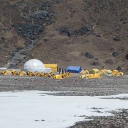
      3,9 km, 600m auf, 600m ab

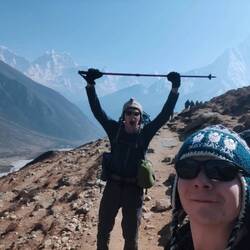
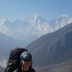
      Heute war es soweit. Das erste große Ziel, die Besteigung des Gokyo Ri, stand auf dem Wanderprogramm. Immer wieder hatten wir uns in schwierigen Situation die Vorstellung in den Kopf gerufen, dass der Gokyo Ri das große Ziel war. Hier sind wir 10 Tage hingelaufen, um genau das zu machen was wir gerade taten: zu laufen und zwar mitten in der Nacht. Um vier Uhr morgens ging es los. Mit Stirnlampen auf dem Kopf gingen wir dicht hintereinander Schritt für Schritt den Berg hinauf. 600 Meter ging es quasi steil bergauf. Jeder Schritt war höher und die Luft immer dünner. Mittlerweile kroch ich wie eine fitte Omi den Berg hinauf und pustete doch mehr als mir lieb war. Aber wir fühlten uns beide dennoch gut. Wir hatten keine Auswirkungen der Höhenkrankheit und stapften artig immer weiter.
      Langsam dämmerte es und wir hatten erst die Hälfte geschafft, also liefen wir so zügig wie möglich weiter. Das Gefühl völlig kraftlos zu sein obwohl man nach der kurzen Zwischenpause nur wenige Schritte gegangen ist, warf einen immer wieder, auch mental, zurück. Aber wir wollten es beide einfach so sehr. Zwischendurch dachten wir, dass wir einfach stehen bleiben sollten und den Sonnenaufgang von dort aus abwartetenen, denn das Licht wurde bereits intensiver. Aber wir pushten uns immer weiter. Die Gipfel der Everest-Kette um uns herum wurden immer klarer und der Himmel immer heller. Zu diesem Zeitpunkt war jeder Schritt nur noch reine Willenskraft, denn körperlich waren wir beide einfach platt und wollten bei JEDEM Schritt am liebsten Pause machen. Doch es zog uns immer weiter keuchend hoch. So erschöpft hatte ich mich zuvor noch nie gefühlt im Leben. Aber die Füße trugen uns weiter.
      David sagte plötzlich: “Da ist sie, die Sonne!” und ich drehte mich um und die warmen, hellen Strahlen trafen uns direkt im Gesicht. Hinter dem Mount Everest blickte sie hervor. Wir waren oben, fielen uns in die Arme und mussten beide vor Glück weinen. Wir waren da. Die vielen Schritte, die Blessuren, die Zeit, der innere Kampf - all das haben wir erreicht, um diesen Moment zu erleben und es es war einer der intensivsten Momente meines Lebens. Der 360° Blick auf die Everest-Range mit dem Cho Oyu, Makalu, Lothse (ebenfalls alles 8.000er), am Horizont der Gletscher, die Seen - es war Frieden auf dem Berg und wir waren für alles dankbar. Über eine Stunde blieben wir oben und genossen das tolle Gefühl, bis wir langsam wieder die 600m runter nach Gokyo liefen.
      Unten angekommen schauten wir uns aufgeregt alle Bilder an und wieder flossen Tränen der Dankbarkeit sowas in seinem Leben erleben zu dürfen.
      もっと詳しく

    • 日20

      Summit Day Lobuche east

      2023年10月29日, ネパール ⋅ ☁️ -3 °C

      2:20 Uhr Tagwache
      3:00 Milchreis und Tee
      3:30 Abmarsch

      steil steiler am steilsten.
      Die ersten 2 Stunden in Dunkelheit gings über Platten hinauf zum Gletscher. Teils mit Seilen versichert, teils zum kraxln. Als wir endlich den Gletscher erreichten und mit Steigeeisen an den Schuhen unsere Tour fortsetzten, gings richtig zur Sache 😅 Steile Rinnen, nur mir Steigklemme möglich, ging es 400hm in meist 45Grad steilen, vereisten Gelände Schritt für Schritt nach oben. 🤩 Bald wärmte uns die Sonne und ließ uns die letzten 150Meter nochmal alles geben 💪🏼 Es war mega hart aber es hat sich mehr als gelohnt.
      Heute standen wir ZUSAMMEN am Gipfel ❤️ 6090m

      Im Hochlager wartete schon Dendi auf uns mit Tee und Nudelsuppe. Danach gabs "restlessn" da dies die letzte Mahlzeit von Dendi war. Ab jetzt sind wir nur noch in Lodges untergebracht und werden in 3 Tagen Lukla erreichen.
      もっと詳しく

    • 日61

      Mount Everest - Basecamp

      2023年12月29日, ネパール ⋅ ☀️ -16 °C

      Frisch aufgetankt ging es weiter Richtung Pheriche, ein kleines Dorf.
      Der Pilot hat sich hat die Sauerstoffflasche angeschlossen- auf dem Weg dahin dann auch aufgedreht. Da wusste man es wird ernst.

      Da sind wir dann etwas unterhalb des Dorfs (ca. 4300m) neben dem Flussbett gelandet und haben die zwei Italiener abgesetzt da wir sonst zu schwer gewesen wären für die weiteren Höhen. Und weiter Richtung Basecamp zu Füßen des Mounteverest. Ein Wahnsinn. Man bekommt ein gutes Gefühl dafür, wie gefährlich es ist dort. Das Ganze unheimlich beeindruckend.

      Das Basecamp liegt auf ca. 5300m, also sind wir in ca. 5500m Höhe da drüber. Man merkt die Höhe übel. Man hat das Gefühl dass man dort nicht hingehört. Für Everest Bergsteiger geht da erst das schlimmste los.

      Das Basecamp selbst ist aktuell leer weil die Saison bereits Ende Mai beendet wurde, nachdem bereits 17 Tote und Rekordanzahl Bergsteiger zu verzeichnen waren.

      Weil das Alles so grenzwertig ist, ist da auch nur ein kurzer Überflug möglich, landen im Basecamp auch nach einem (weiteren) Heli-Unfall im Oktober nicht mehr erlaubt.

      Dann wieder zurück nach Pheriche und mit den Italienern getauscht und somit ein bisschen Zeit sich ein bisschen umzuschauen.
      もっと詳しく

    • 日11

      Trekking til Pikey Peak og Junbesi

      3月17日, ネパール ⋅ ☁️ 7 °C

      Vi har nu haft fire vandredage i Himalaya 🥾

      Den første dag stod på en let vandretur på en 4-5 timer (fra Dhap til Jhabre). Hele vejen blev vi fulgt af en hund, som så lidt medtaget ud. Vi kaldte ham Gustav. Gustav tog simpelthen med hen og overnattede ved vores tehus i Jhabre. I tehuset faldt vi i snak med en flok jævnaldrende tyskere, samt en østrigsk kvinde, som alle skal ud på nogenlunde den samme rute ved 'Pikey peak'.

      Dagen derpå forsøgte Gustav at følge med os videre, men vi fik ham til at blive tilbage. Dagen stod på et længere og hårdere trek, hvor vi skulle gå i 7-8 timer med en masse højdemeter. Her skulle vi ende ved 'basecamp' til Pikey peak og overnatte i et tehus beliggende i ca. 3700 m.o.h. På vejen spiste vi frokost ved et lokalt lille køkken, og her mødte vi igen tyskerne... - og Gustav! Han var simpelthen fulgt med dem, så nu begyndte han at være langt hjemmefra 😅 Heldigvis kom en flok trekkere den modsatte vej, og Gustav gik nu med dem, så forhåbentligt kommer han godt hjem igen 🤞🏻 I basecampen var der masser liv og sniksnak om aftenen. Her boede vi bl.a. sammen med tyskerne fra tidligere, et par amerikanere og nogle mountainbikere. Alle skulle tidligt op, for at kunne nå op til solopgang på Pikey peak dagen derpå 🌻

      Som sagt så gjort; i går stod vi op, så vi var klar til at gå kl. 4.30, så vi kunne se solopgangen på toppen (4067 m.o.h). Der var helt stjerneklart, og vi kæmpede os op af bjerget iklædt varmt tøj og pandelygter. Kl. 5.40 var vi fremme på toppen, og hold nu op en udsigt! Her havde vi den smukkeste morgen med udsigt over til store bjergkæder; og nåhr ja, så kunne vi da også se Mount Everest 😎

      Herefter skulle vi egentlig bare gå ned ad i ca. To timer, og så var vi fremme ved et nyt tehus (i Jasmane Bhanjyang), hvor vi skulle have en rigtig slappe-dappe-dag. Vi fik læst, sovet lur, og badet (okay, vi fik en spand varm vand og sæbe), og så spiste vi en masse 'momo', som er en slags Tibetansk dumpling 🥟

      I dag er vi gået videre til bjergbyen Junbesi (5-6 timers trek). Da vi vågnede i morges, var det overskyet, og mens vi spiste morgenmad så vi et par enkelte snefnug falde. Sneen tog dog til, og de første timer gik vi i snevejr, og undervejs fik vi brug for kæder om skoene, så vi ikke skøjtede rundt Heldigvis var det kun i en kort strækning, at det var nødvendigt. Vi fik frokost i et tehus på vejen. Her var der tændt op i brændeovnen og vi kunne varme samt tørre os selv og vores grej, inden vores videre færd. Efter nogle timer i støvregn kom vi endelig frem til tehuset i Junbesi. Her mødte vi igen tyskerne og østrigeren, så det er smadder hyggeligt, at man efterhånden kender hinanden. Nu sidder vi i fællesrummet, nogle spiller kort, andre læser, og nogle tyske pensionister har købt øl fra hjemlandet. Det kan altså noget det her trekkingliv 🥾😁⛰️
      もっと詳しく

    • 日12

      Day 12: Goli Gumba to Pikey Pk Base Camp

      4月1日, ネパール ⋅ ☀️ 17 °C

      Three whole kilometres of flat ground? Surely an April Fools' joke, we thought, but no. A gentle start from Goli Gumba eased us into the day's walking until we reached a dusty ascent, where some locals who were trying to kick a motorbike into gear (at 3000 m of all places) took an interest in us, and resulted in a bit of a bizarre selfie. What followed was a moderate climb through mossy, enchanting woods, which seemed to be dripping in colour: of red rhododendrons, blue blooms of flowers, rich in green shrubs, and bountiful in butterflies, especially given the altitude.

      The journey was honestly a peaceful and enjoyable one, and it felt like no time at all until we'd pulled into a little teahouse for some chow mein lunch at 3400 m, with the growing Himalayan range staring back at us. The Nepalese who we came across at that teahouse were exceptionally hardy people, and we saw the old lady who we figured must've been in her eighties and a lama at the adjoining monastery, hauling a giant basket of firewood up the steps all while balancing the load with nothing more than her head (!) I don't know about your nan, but my nan struggles to walk in a straight line while carrying a cup of tea in her living room even (bless her), god knows how she'd fare with a ton of bricks on Kilimanjaro (sorry nan.)

      Our final stretch of ascent was drawn out over the next few hours as we battled a shortness of breath due to the dwindling atmospheric oxygen, while passing little patches of ice on our way up to Pikey Peak base camp at an altitude of 3730 m. Here, we were surprised to see one thing, other trekkers?! Where the hell have they come from, and why are there suddenly so many? Realising that we won't be enjoying much solitude beyond this stage, I think we both have renewed cheer for how we'd chosen to do the previous sections, having enjoyed whole teahouses to ourselves literally every day. Still, with the chance to talk to some fluent English speakers, we met a South African couple who'd been travelling for over 2 years straight, survived death from a Laotian bus crash, and where the husband had been an understudy to Archbishop Desmond Tutu back when he worked. Pretty cool. And with that, we set down the shutters and prepared for a 4:30 am awakening to ambush Pikey Peak at dawn.

      P.S. First day without signal so you won't see this as I write it!
      もっと詳しく

    • 日14

      Day 14: Junbesi to Ringmu

      4月3日, ネパール ⋅ ⛅ 16 °C

      Leaving our packs behind in Junbesi, we decided to take a short break out of our trek and instead took a morning stroll up to Thubten Choling, the largest Buddhist monastery in Nepal. A huge untroubled community of nuns and monks living harmoniously in a 3000 m village embellished with intricate colourful ornaments. I have to say, it's the first time I've ever visited any place of religious significance and realised that this could easily be a salvation for its members. We saw the prayer wheels inscribed with mantras rotating due to the cleverly engineered flow of water, while robe-wearing monks roamed between vibrant buildings amid tranquil chiming and all the children seemed to be learning to make pottery at school. After wandering questionably into a very holy looking building, we found a place to buy some prayer flags, beautifully hand painted postcards, and a notebook handmade with an ancient paper making technique. It was such a peaceful place, and honestly, I'm not religious myself, but if I was, Buddhism would be the one for me. (And we did also buy toilet paper there, so maybe that'll make my holes holy after all?)

      Returning to our lodge in Junbesi, we each devoured another of our favourite pizzas yet and some cadbury's we'd wangled at a shop, before making haste in the heat onward on the trail. A stuffy ascent sent us up to Phurtheng, where I decided to stop to enjoy the view over a cup of tea. Here, the host of the teahouse was a very sweet guy, a Sherpa who had lived there his whole life, and entertained our stop by explaining the extent of the traditional route and how the sections from Jiri had suffered hugely in business since most people now choose to fly into Lukla. One thing about him, just as is common with many Nepalis, was just how humble he was, placing his hands together almost in prayer and grinning with a huge smile in response to every 'namaste'. Ending the day with a further down then up through a valley via a hanging bridge, we have called it a day in Ringmu, where a busier teahouse continues to wane our wearies.
      もっと詳しく

    • 日16

      Day 16: Jubing to Puiya

      4月5日, ネパール ⋅ ☁️ 8 °C

      If yesterday was the downhill day, then today was definitely the uphill one, with 1,500+ m of steep ascents up through Kharikhola, Bupsa and Kari La.

      Before all that scrambling though, just leaving for the morning as usual became something of a struggle. And not for any of the normal reasons: as we'd left our window open while packing up our things, a monstrous winged beast kamikazed its way into our room like some buzzing Chinook locking onto its target. We both took one look at this thing and noped our way out of that situation, fleeing our room without hesitation, deserting our belongings and hiding behind the door from the wrong side. This insect, which we later discovered to be called a mammoth wasp (literal species name), was MASSIVE, with a chunky black torso and a buzz like an industrial lawn mower. Once we'd waited out the 'death hornet' as we'd called it, to leave back out through the window from which it came, we were able to make our way, but quickly came across another oddity in nature, witnessing streams of caterpillars following one another everywhere and all over the forest, apparently going off on little adventures to pupate into butterflies together.

      On the more human side of the climb however, our progress was slow in the heat, and we worked our way laboriously up to Bupsa for some lunch. Here, Thomas was particularly feeling some struggles on the ascent, but we took the time to unwind over some mango juice and spaghetti while a small Nepalese toddler took an eager interest in us. The way up from Bupsa to Kari La proved much friendlier despite the elevation gain, especially with the wider, more gentle paths which are used for jeeps up until Thamdanda. Between Kari La and Puiya, we witnessed whole herds of horses (or maybe mules given their donkey likenesses?) hauling supplies and gas bottles up the mountainside, and then the end of the road (/dirt track) where colossal landslides had taken place, trapping some vehicles and straight up destroying others. This evening, we've styled out our exhaustion by going head to head playing cards, where of course I won, (but Thomas might tell you differently.)
      もっと詳しく

    • 日23

      Day 23: Dingboche to Lobuche

      4月12日, ネパール ⋅ ☀️ -4 °C

      We tried to navigate our own way around a lump of earth straight out of Dingboche to avoid climbing it (for no reason other than we're lazy to be honest) and in doing so, accidentally took an unnecessarily indirect route to the start of the path towards Lobuche.

      The route which followed was a dusty and gentle incline, but with the altitude it soon became apparent that Thomas was struggling with lethargy and lack of being able to take a satisfying breath. And it's true, everything and anything can tire you out up here and it does make you feel extremely slow. But after he managed to collect some air, we shuffled on towards Thok La pass, negotiating a half-frozen stream set in the moraine on our way. Thok La was the most tiring portion of the day, another upward endurance test where stopping every few steps became basically mandatory. But once we finally reached the top, there were mass monuments to all those who had died on Everest down the years, while the outrageous view from every direction was joined by a new glaciated feature: Pumori peak. With the ground levelling out, we entered the final valley which leads up to Everest Base Camp, and new peaks unfolded as appropriate. Rolling into Lobuche, it's been business as usual in unwinding and recollecting our sanity at a teahouse, this time at an altitude of 4,920 m. If all goes to plan, and we weather the -30°C night (possibly exaggerating but not sure), tomorrow we hit Everest Base Camp.
      もっと詳しく

    • 日24

      Day 24: Everest Base Camp

      4月13日, ネパール ⋅ ☀️ -12 °C

      Time for a much overdue footprint if phone signal permits. Our experience of Lobuche was relatively pleasant and the night nowhere near as cold as we'd expected.

      Our first mission getting going for the day: get to Gorak Shep. Gorak Shep is the highest settlement anywhere before Everest Base Camp at an altitude of 5150 m, where atmospheric oxygen levels are 50% what they are at sea level, so as you can imagine, everything feels a lot more lethargic up there.

      This section was split into two parts: the first, a gentle amble up the valley; the second, a tiring scramble up, down, forward, and back over the glacier's scattered scree. After a few draining hours, we reached Gorak Shep and whacked down our big bags into our room, before slumping into the dining room for some lunch. At this point, Thomas confessed his questionable condition (altitude sickness is a bit like that, you can feel decidedly unwell but sort of confused as to how?), while I was also showing some signs of being worse for wear (namely, extreme tiredness and an aggravated cough famously dubbed as the Khumbu cough.) Anyhow, we mustered our strength and decided to push onto Base Camp while we still had the chance.

      By this point in the day, the regular afternoon clouds had begun to roll in, and the mild-sounding 2 miles onto Base Camp was beginning to drag, as we again navigated haphazard boulder fields which mounted the glacier. Turning a corner, you get your first glimpse of Base Camp itself, practically a vast city of yellow and orange tents which sprawl precariously all the way up to the Khumbu icefall. With our destination in line of sight, we descended a ridge and just like that, we'd made it!

      We afforded some subdued celebrations, hugging each other and enjoying the 5,364 m altitude as our trek's main objective. We then joined the queue (yes, queue) to get a picture with the famous 'Everest Base Camp' boulder and newly installed Hillary and Norgay sign where we commemorated our place under the world's tallest mountain with some quietly pleased pics.

      As we still mooched around at Base Camp, the heavy clouds began to spew spatterings of snow down: the start of the 5 cm of snowfall forecast for the afternoon! Fearing a blizzard, we lumbered our way back to Gorak Shep, admiring the surroundings as they turned from snow-dusted to snow-buried. Still, we got back in one piece (or two pieces), tucked away some food, and hunkered down for the coldest night yet: Gorak Shep is so high and so cold that they don't even have water.
      もっと詳しく

    • 日25

      Day 25: Kala Patthar

      4月14日, ネパール ⋅ ☀️ -12 °C

      Everest Base Camp may be what everyone sets out to do, but in my opinion, Kala Patthar is the real jewel in the trekking crown. Kala Patthar is a 5,645 m vantage point with gorgeous vistas over mahoosive peaks in every direction. It sits some 300 metres above Base Camp and comes with an even more stark view of Everest unlike any we'd seen before. So with the hour barely 6 am as we departed Gorak Shep, we were delighted to bear witness to the perfect conditions: shimmering snow, unblemished blue skies, and the sun's rays gently easing in the day from over the Himalayan horizon. It was peaceful bliss. Or at least it would've been if not for the punishing ascending altitude we were about to undertake.

      As we began our ascent, we were surprised to see other trekkers descending already, at 6 am? That's keen, we thought, as we continued to shuffle our way up the icy incline. Thomas seemed to be coping okay but I've got to say, it was the hardest 'easy' climb I've ever done; wheezing for breath after every few steps and ascending in painful slow motion. I say 'easy' climb because, if not for the altitude, it really should've been. But my god, altitudes that high can be crippling not only on the legs, but on the lungs, and even the brain too, taking sheer determination to stagger to the summit. It had taken us three hours to complete the 500 m of ascent, and our prize: front row seats in an amphitheatre of dramatic snow-capped mountains, headed by its showpiece: Mt Everest, the tallest on Earth. Perhaps ironically though, Everest was probably one of the less impressive views, with Pumori, Lingtren and the nearer Nuptse jarring into the sky, all appearing larger. Still, we lingered on the view out in every direction, and gawped at the climbers' route up to Everest's summit via the wild Khumbu icefall and lumpy Hillary step. Here, we also enjoyed some more enthusiastic celebrations and snapped plenty of photos in the still solitude of the summit. I also got to wave my Kala Patthar hat from the very place it described.

      The descent back down was much more brisk, and upon returning to the teahouse, we decided on the first food of the day. I knew something wasn't quite right: I'd felt hungry, but also that I didn't want to eat. Still, I picked away at a pancake and we eventually set off on our way back down. We'd made it barely a few steps out from the front of the teahouse when I then paused to put on my sunglasses, turned, and threw up both violently and repeatedly. Shit. Vomiting isn't a particularly good sign when it comes to altitude, and combined with the symptoms both Thomas and I had been experiencing over the previous couple of days, we decided we needed to take more responsible action and adapt our plans. We had previously intended on attempting the giant Cho La pass over a glacier to Gokyo lake, thus hoping to end today in the village of Dzongla. But feeling rough in ourselves, we instead descended back to Lobuche, where we'd evaluate our plans going forward.
      もっと詳しく

    この場所は、次の名前で知っているかもしれません:

    Purwanchal, Eastern Region, 동부 개발 지구, पूर्वाञ्चल विकास क्षेत्र

    参加する:

    FindPenguins for iOSFindPenguins for Android